You are here: Home > Network List > US - United States National Seismic Network Stations List
> Station EGMT Eagleton, Montana, USA > Earthquake Result Viewer
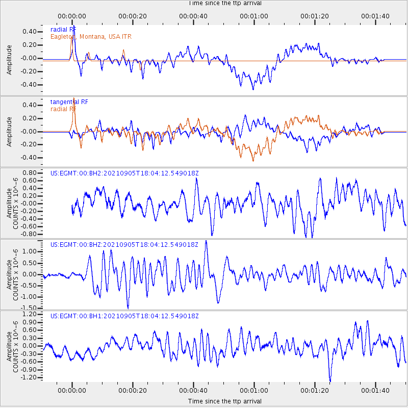
EGMT Eagleton, Montana, USA - Earthquake Result Viewer
*The percent match for this event was below the threshold and hence no stack was calculated.
| Earthquake location: |
Tonga Islands Region |
| Earthquake latitude/longitude: |
-22.1/-174.2 |
| Earthquake time(UTC): |
2021/09/05 (248) 17:51:42 GMT |
| Earthquake Depth: |
10 km |
| Earthquake Magnitude: |
5.9 mww |
| Earthquake Catalog/Contributor: |
NEIC PDE/us |
|
| Network: |
US United States National Seismic Network |
| Station: |
EGMT Eagleton, Montana, USA |
| Lat/Lon: |
48.02 N/109.75 W |
| Elevation: |
1055 m |
|
| Distance: |
90.5 deg |
| Az: |
37.263 deg |
| Baz: |
236.776 deg |
| Ray Param: |
$rayparam |
*The percent match for this event was below the threshold and hence was not used in the summary stack. |
|
| Radial Match: |
64.52281 % |
| Radial Bump: |
400 |
| Transverse Match: |
59.250347 % |
| Transverse Bump: |
400 |
| SOD ConfigId: |
25131211 |
| Insert Time: |
2021-09-19 18:13:09.091 +0000 |
| GWidth: |
2.5 |
| Max Bumps: |
400 |
| Tol: |
0.001 |
|
Signal To Noise
| Channel | StoN | STA | LTA |
| US:EGMT:00:BHZ:20210905T18:04:12.549018Z | 1.1147956 | 8.9945665E-8 | 8.068355E-8 |
| US:EGMT:00:BH1:20210905T18:04:12.549018Z | 2.7424302 | 6.383047E-7 | 2.3275147E-7 |
| US:EGMT:00:BH2:20210905T18:04:12.549018Z | 0.61564624 | 1.2562296E-7 | 2.0405055E-7 |
| Arrivals |
| Ps | |
| PpPs | |
| PsPs/PpSs | |


