You are here: Home > Network List > XS99 - Montana BB Array Stations List
> Station S07 XS.S07 > Earthquake Result Viewer
S07 XS.S07 - Earthquake Result Viewer
| Earthquake location: |
Iceland |
| Earthquake latitude/longitude: |
64.0/-20.8 |
| Earthquake time(UTC): |
2000/06/21 (173) 00:51:46 GMT |
| Earthquake Depth: |
10 km |
| Earthquake Magnitude: |
6.1 MB, 6.6 MS, 6.5 MW, 6.4 MW |
| Earthquake Catalog/Contributor: |
WHDF/NEIC |
|
| Network: |
XS Montana BB Array |
| Station: |
S07 XS.S07 |
| Lat/Lon: |
45.57 N/109.74 W |
| Elevation: |
1800 m |
|
| Distance: |
49.9 deg |
| Az: |
293.324 deg |
| Baz: |
35.215 deg |
| Ray Param: |
0.06841531 |
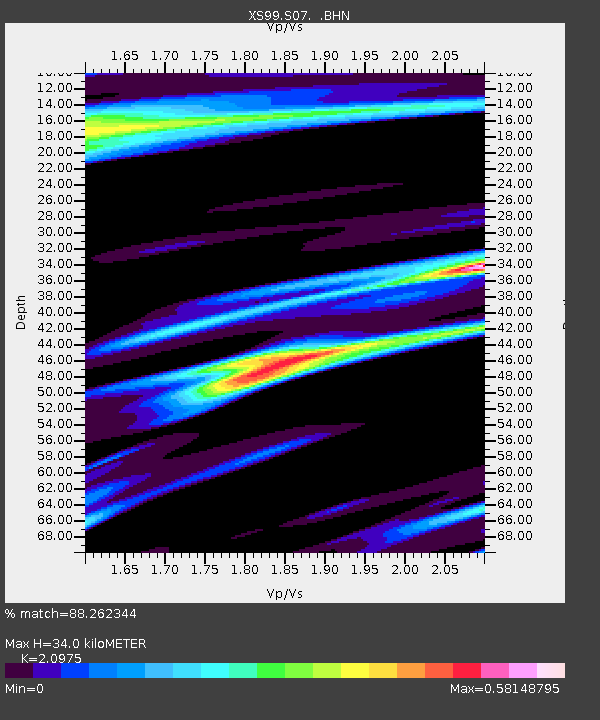
| Estimated Moho Depth: |
34.0 km |
| Estimated Crust Vp/Vs: |
2.10 |
| Assumed Crust Vp: |
6.242 km/s |
| Estimated Crust Vs: |
2.976 km/s |
| Estimated Crust Poisson's Ratio: |
0.35 |
|
| Radial Match: |
88.262344 % |
| Radial Bump: |
400 |
| Transverse Match: |
71.9165 % |
| Transverse Bump: |
400 |
| SOD ConfigId: |
20082 |
| Insert Time: |
2010-03-09 12:31:44.327 +0000 |
| GWidth: |
2.5 |
| Max Bumps: |
400 |
| Tol: |
0.001 |
|

Signal To Noise
| Channel | StoN | STA | LTA |
| XS:S07: :BHN:20000621T01:00:09.399012Z | 4.281201 | 7.7142954E-7 | 1.8019E-7 |
| XS:S07: :BHE:20000621T01:00:09.399012Z | 1.2688684 | 6.488719E-7 | 5.113784E-7 |
| XS:S07: :BHZ:20000621T01:00:09.399012Z | 5.0892663 | 2.6721561E-6 | 5.2505726E-7 |
| Arrivals |
| Ps | 6.3 SECOND |
| PpPs | 16 SECOND |
| PsPs/PpSs | 22 SECOND |


