You are here: Home > Network List > AK - Alaska Regional Network Stations List
> Station L22K Petersville, AK, USA > Earthquake Result Viewer
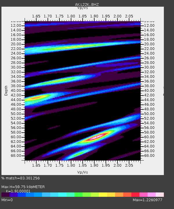
L22K Petersville, AK, USA - Earthquake Result Viewer
| Earthquake location: |
Fiji Islands Region |
| Earthquake latitude/longitude: |
-19.4/-176.1 |
| Earthquake time(UTC): |
2021/09/07 (250) 09:49:57 GMT |
| Earthquake Depth: |
10 km |
| Earthquake Magnitude: |
5.8 mww |
| Earthquake Catalog/Contributor: |
NEIC PDE/us |
|
| Network: |
AK Alaska Regional Network |
| Station: |
L22K Petersville, AK, USA |
| Lat/Lon: |
62.53 N/150.77 W |
| Elevation: |
817 m |
|
| Distance: |
84.1 deg |
| Az: |
11.49 deg |
| Baz: |
203.915 deg |
| Ray Param: |
0.045736935 |
| Estimated Moho Depth: |
59.75 km |
| Estimated Crust Vp/Vs: |
1.91 |
| Assumed Crust Vp: |
6.438 km/s |
| Estimated Crust Vs: |
3.371 km/s |
| Estimated Crust Poisson's Ratio: |
0.31 |
|
| Radial Match: |
83.381256 % |
| Radial Bump: |
400 |
| Transverse Match: |
73.15267 % |
| Transverse Bump: |
400 |
| SOD ConfigId: |
25131211 |
| Insert Time: |
2021-09-21 09:52:51.197 +0000 |
| GWidth: |
2.5 |
| Max Bumps: |
400 |
| Tol: |
0.001 |
|

Signal To Noise
| Channel | StoN | STA | LTA |
| AK:L22K: :BHZ:20210907T10:01:56.579985Z | 5.61002 | 2.859365E-7 | 5.0968886E-8 |
| AK:L22K: :BHN:20210907T10:01:56.579985Z | 2.1229181 | 9.3580894E-8 | 4.4081254E-8 |
| AK:L22K: :BHE:20210907T10:01:56.579985Z | 1.6732682 | 9.622678E-8 | 5.750828E-8 |
| Arrivals |
| Ps | 8.6 SECOND |
| PpPs | 26 SECOND |
| PsPs/PpSs | 35 SECOND |


