You are here: Home > Network List > AV - Alaska Volcano Observatory Stations List
> Station CAHL Cahill, Katmai, Alaska > Earthquake Result Viewer
CAHL Cahill, Katmai, Alaska - Earthquake Result Viewer
| Earthquake location: |
Fiji Islands Region |
| Earthquake latitude/longitude: |
-19.4/-176.1 |
| Earthquake time(UTC): |
2021/09/07 (250) 09:49:57 GMT |
| Earthquake Depth: |
10 km |
| Earthquake Magnitude: |
5.8 mww |
| Earthquake Catalog/Contributor: |
NEIC PDE/us |
|
| Network: |
AV Alaska Volcano Observatory |
| Station: |
CAHL Cahill, Katmai, Alaska |
| Lat/Lon: |
58.05 N/155.30 W |
| Elevation: |
807 m |
|
| Distance: |
79.1 deg |
| Az: |
11.064 deg |
| Baz: |
199.918 deg |
| Ray Param: |
0.049214948 |
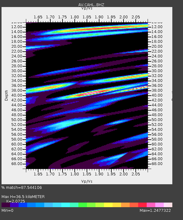
| Estimated Moho Depth: |
36.5 km |
| Estimated Crust Vp/Vs: |
2.07 |
| Assumed Crust Vp: |
6.438 km/s |
| Estimated Crust Vs: |
3.107 km/s |
| Estimated Crust Poisson's Ratio: |
0.35 |
|
| Radial Match: |
87.544106 % |
| Radial Bump: |
400 |
| Transverse Match: |
68.67633 % |
| Transverse Bump: |
400 |
| SOD ConfigId: |
25131211 |
| Insert Time: |
2021-09-21 09:55:30.497 +0000 |
| GWidth: |
2.5 |
| Max Bumps: |
400 |
| Tol: |
0.001 |
|

Signal To Noise
| Channel | StoN | STA | LTA |
| AV:CAHL: :BHZ:20210907T10:01:30.220Z | 2.8837507 | 2.8370155E-7 | 9.837935E-8 |
| AV:CAHL: :BHN:20210907T10:01:30.220Z | 1.2347865 | 1.0703923E-7 | 8.668643E-8 |
| AV:CAHL: :BHE:20210907T10:01:30.220Z | 1.143489 | 1.0676664E-7 | 9.336919E-8 |
| Arrivals |
| Ps | 6.2 SECOND |
| PpPs | 17 SECOND |
| PsPs/PpSs | 23 SECOND |


