You are here: Home > Network List > AV - Alaska Volcano Observatory Stations List
> Station KAB2 Katmai Barrier Ridge Two, Alaska > Earthquake Result Viewer
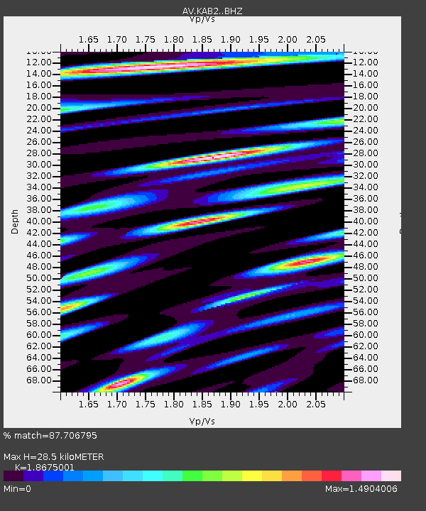
KAB2 Katmai Barrier Ridge Two, Alaska - Earthquake Result Viewer
| Earthquake location: |
Fiji Islands Region |
| Earthquake latitude/longitude: |
-19.4/-176.1 |
| Earthquake time(UTC): |
2021/09/07 (250) 09:49:57 GMT |
| Earthquake Depth: |
10 km |
| Earthquake Magnitude: |
5.8 mww |
| Earthquake Catalog/Contributor: |
NEIC PDE/us |
|
| Network: |
AV Alaska Volcano Observatory |
| Station: |
KAB2 Katmai Barrier Ridge Two, Alaska |
| Lat/Lon: |
58.13 N/154.98 W |
| Elevation: |
908 m |
|
| Distance: |
79.2 deg |
| Az: |
11.203 deg |
| Baz: |
200.222 deg |
| Ray Param: |
0.049125087 |
| Estimated Moho Depth: |
28.5 km |
| Estimated Crust Vp/Vs: |
1.87 |
| Assumed Crust Vp: |
6.438 km/s |
| Estimated Crust Vs: |
3.448 km/s |
| Estimated Crust Poisson's Ratio: |
0.30 |
|
| Radial Match: |
87.706795 % |
| Radial Bump: |
400 |
| Transverse Match: |
73.03178 % |
| Transverse Bump: |
400 |
| SOD ConfigId: |
25131211 |
| Insert Time: |
2021-09-21 09:55:54.483 +0000 |
| GWidth: |
2.5 |
| Max Bumps: |
400 |
| Tol: |
0.001 |
|

Signal To Noise
| Channel | StoN | STA | LTA |
| AV:KAB2: :BHZ:20210907T10:01:30.959013Z | 4.2670794 | 1.44943E-7 | 3.396773E-8 |
| AV:KAB2: :BHN:20210907T10:01:30.959013Z | 1.9627918 | 9.093164E-8 | 4.6327706E-8 |
| AV:KAB2: :BHE:20210907T10:01:30.959013Z | 1.4800088 | 7.6142676E-8 | 5.1447447E-8 |
| Arrivals |
| Ps | 3.9 SECOND |
| PpPs | 12 SECOND |
| PsPs/PpSs | 16 SECOND |


