You are here: Home > Network List > AV - Alaska Volcano Observatory Stations List
> Station KAWH Katmai, Alaska > Earthquake Result Viewer
KAWH Katmai, Alaska - Earthquake Result Viewer
| Earthquake location: |
Fiji Islands Region |
| Earthquake latitude/longitude: |
-19.4/-176.1 |
| Earthquake time(UTC): |
2021/09/07 (250) 09:49:57 GMT |
| Earthquake Depth: |
10 km |
| Earthquake Magnitude: |
5.8 mww |
| Earthquake Catalog/Contributor: |
NEIC PDE/us |
|
| Network: |
AV Alaska Volcano Observatory |
| Station: |
KAWH Katmai, Alaska |
| Lat/Lon: |
58.38 N/154.80 W |
| Elevation: |
777 m |
|
| Distance: |
79.5 deg |
| Az: |
11.202 deg |
| Baz: |
200.37 deg |
| Ray Param: |
0.048939846 |
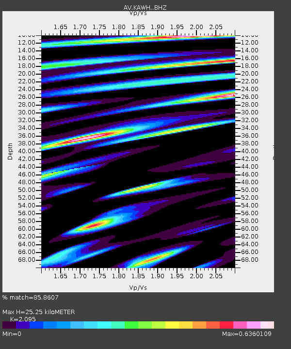
| Estimated Moho Depth: |
25.25 km |
| Estimated Crust Vp/Vs: |
2.10 |
| Assumed Crust Vp: |
6.438 km/s |
| Estimated Crust Vs: |
3.073 km/s |
| Estimated Crust Poisson's Ratio: |
0.35 |
|
| Radial Match: |
85.8607 % |
| Radial Bump: |
400 |
| Transverse Match: |
82.254074 % |
| Transverse Bump: |
400 |
| SOD ConfigId: |
25131211 |
| Insert Time: |
2021-09-21 09:56:02.688 +0000 |
| GWidth: |
2.5 |
| Max Bumps: |
400 |
| Tol: |
0.001 |
|

Signal To Noise
| Channel | StoN | STA | LTA |
| AV:KAWH: :BHZ:20210907T10:01:32.420012Z | 3.2905655 | 1.10069685E-7 | 3.3450082E-8 |
| AV:KAWH: :BHN:20210907T10:01:32.420012Z | 1.1586416 | 3.8123808E-8 | 3.290388E-8 |
| AV:KAWH: :BHE:20210907T10:01:32.420012Z | 1.1446956 | 4.6080054E-8 | 4.0255287E-8 |
| Arrivals |
| Ps | 4.4 SECOND |
| PpPs | 12 SECOND |
| PsPs/PpSs | 16 SECOND |


