You are here: Home > Network List > AV - Alaska Volcano Observatory Stations List
> Station SPCL Chakachamna Lake, Mount Spurr, Alaska > Earthquake Result Viewer
SPCL Chakachamna Lake, Mount Spurr, Alaska - Earthquake Result Viewer
| Earthquake location: |
Fiji Islands Region |
| Earthquake latitude/longitude: |
-19.4/-176.1 |
| Earthquake time(UTC): |
2021/09/07 (250) 09:49:57 GMT |
| Earthquake Depth: |
10 km |
| Earthquake Magnitude: |
5.8 mww |
| Earthquake Catalog/Contributor: |
NEIC PDE/us |
|
| Network: |
AV Alaska Volcano Observatory |
| Station: |
SPCL Chakachamna Lake, Mount Spurr, Alaska |
| Lat/Lon: |
61.20 N/152.34 W |
| Elevation: |
1274 m |
|
| Distance: |
82.6 deg |
| Az: |
11.331 deg |
| Baz: |
202.514 deg |
| Ray Param: |
0.04680705 |
| Estimated Moho Depth: |
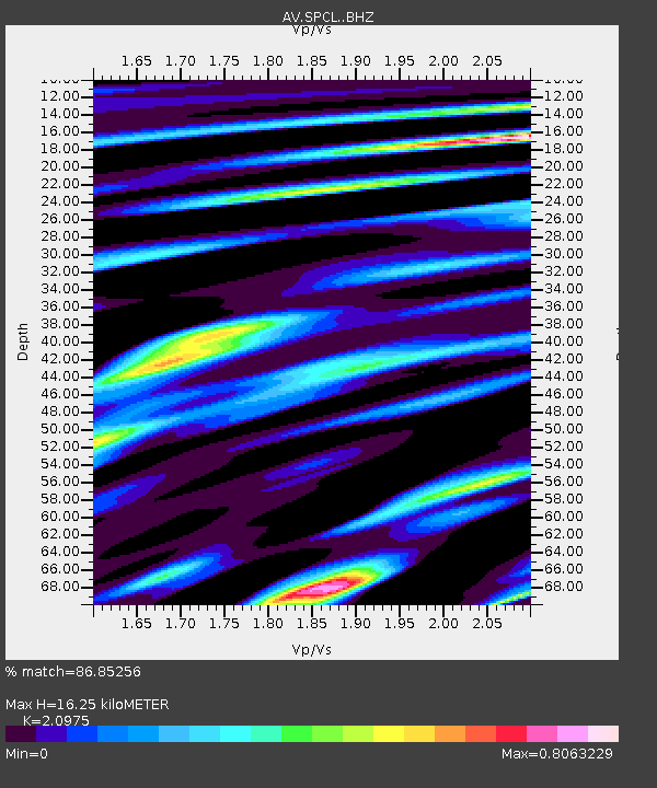
16.25 km |
| Estimated Crust Vp/Vs: |
2.10 |
| Assumed Crust Vp: |
6.566 km/s |
| Estimated Crust Vs: |
3.13 km/s |
| Estimated Crust Poisson's Ratio: |
0.35 |
|
| Radial Match: |
86.85256 % |
| Radial Bump: |
400 |
| Transverse Match: |
69.62404 % |
| Transverse Bump: |
400 |
| SOD ConfigId: |
25131211 |
| Insert Time: |
2021-09-21 09:56:53.327 +0000 |
| GWidth: |
2.5 |
| Max Bumps: |
400 |
| Tol: |
0.001 |
|

Signal To Noise
| Channel | StoN | STA | LTA |
| AV:SPCL: :BHZ:20210907T10:01:48.779021Z | 4.555572 | 1.8705074E-7 | 4.1059774E-8 |
| AV:SPCL: :BHN:20210907T10:01:48.779021Z | 1.5811653 | 8.459039E-8 | 5.3498763E-8 |
| AV:SPCL: :BHE:20210907T10:01:48.779021Z | 1.1352477 | 5.6213622E-8 | 4.951661E-8 |
| Arrivals |
| Ps | 2.8 SECOND |
| PpPs | 7.5 SECOND |
| PsPs/PpSs | 10 SECOND |


