You are here: Home > Network List > CI - Caltech Regional Seismic Network Stations List
> Station MPM Manuel Prospect Mine, California, USA > Earthquake Result Viewer
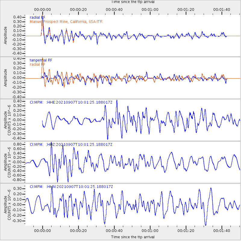
MPM Manuel Prospect Mine, California, USA - Earthquake Result Viewer
*The percent match for this event was below the threshold and hence no stack was calculated.
| Earthquake location: |
Fiji Islands Region |
| Earthquake latitude/longitude: |
-19.4/-176.1 |
| Earthquake time(UTC): |
2021/09/07 (250) 09:49:57 GMT |
| Earthquake Depth: |
10 km |
| Earthquake Magnitude: |
5.8 mww |
| Earthquake Catalog/Contributor: |
NEIC PDE/us |
|
| Network: |
CI Caltech Regional Seismic Network |
| Station: |
MPM Manuel Prospect Mine, California, USA |
| Lat/Lon: |
36.06 N/117.49 W |
| Elevation: |
185 m |
|
| Distance: |
78.2 deg |
| Az: |
44.947 deg |
| Baz: |
235.378 deg |
| Ray Param: |
$rayparam |
*The percent match for this event was below the threshold and hence was not used in the summary stack. |
|
| Radial Match: |
78.44974 % |
| Radial Bump: |
400 |
| Transverse Match: |
69.75462 % |
| Transverse Bump: |
400 |
| SOD ConfigId: |
25131211 |
| Insert Time: |
2021-09-21 10:00:41.457 +0000 |
| GWidth: |
2.5 |
| Max Bumps: |
400 |
| Tol: |
0.001 |
|
Signal To Noise
| Channel | StoN | STA | LTA |
| CI:MPM: :HHZ:20210907T10:01:25.188017Z | 4.850108 | 2.901276E-7 | 5.981879E-8 |
| CI:MPM: :HHN:20210907T10:01:25.188017Z | 1.0986645 | 6.5787326E-8 | 5.987936E-8 |
| CI:MPM: :HHE:20210907T10:01:25.188017Z | 0.8645236 | 6.949055E-8 | 8.038016E-8 |
| Arrivals |
| Ps | |
| PpPs | |
| PsPs/PpSs | |


