You are here: Home > Network List > CI - Caltech Regional Seismic Network Stations List
> Station SWS Sam W. Stewart, Westmorland, CA, USA > Earthquake Result Viewer
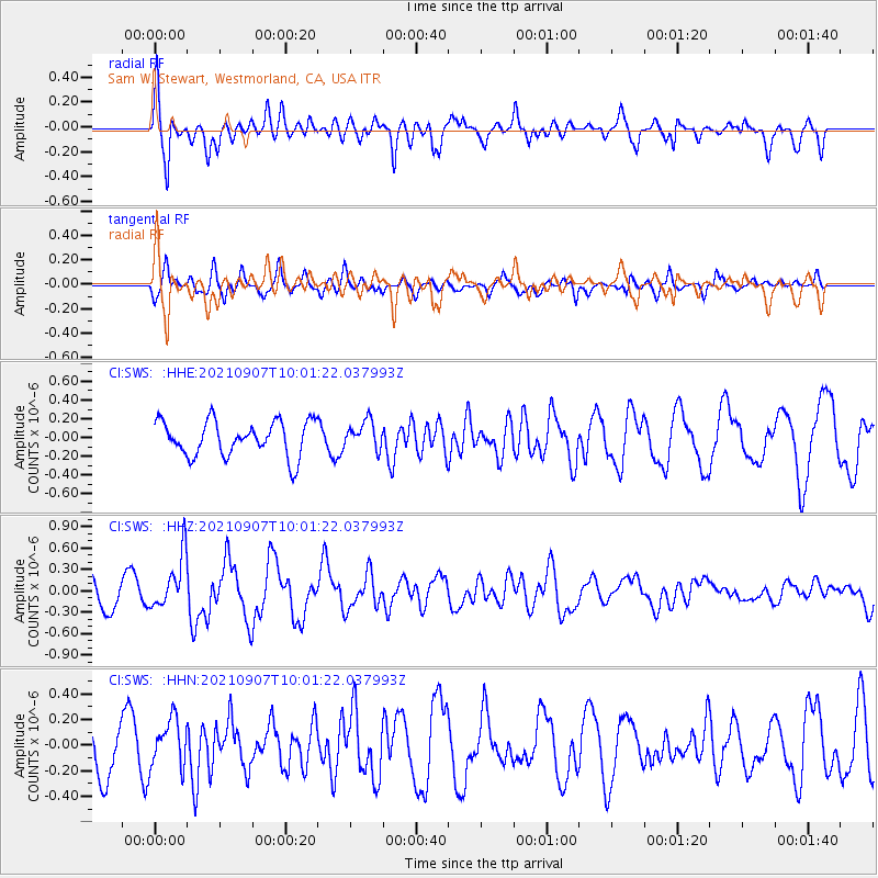
SWS Sam W. Stewart, Westmorland, CA, USA - Earthquake Result Viewer
*The percent match for this event was below the threshold and hence no stack was calculated.
| Earthquake location: |
Fiji Islands Region |
| Earthquake latitude/longitude: |
-19.4/-176.1 |
| Earthquake time(UTC): |
2021/09/07 (250) 09:49:57 GMT |
| Earthquake Depth: |
10 km |
| Earthquake Magnitude: |
5.8 mww |
| Earthquake Catalog/Contributor: |
NEIC PDE/us |
|
| Network: |
CI Caltech Regional Seismic Network |
| Station: |
SWS Sam W. Stewart, Westmorland, CA, USA |
| Lat/Lon: |
32.94 N/115.80 W |
| Elevation: |
140 m |
|
| Distance: |
77.6 deg |
| Az: |
48.386 deg |
| Baz: |
237.056 deg |
| Ray Param: |
$rayparam |
*The percent match for this event was below the threshold and hence was not used in the summary stack. |
|
| Radial Match: |
77.15635 % |
| Radial Bump: |
399 |
| Transverse Match: |
68.00876 % |
| Transverse Bump: |
400 |
| SOD ConfigId: |
25131211 |
| Insert Time: |
2021-09-21 10:01:10.897 +0000 |
| GWidth: |
2.5 |
| Max Bumps: |
400 |
| Tol: |
0.001 |
|
Signal To Noise
| Channel | StoN | STA | LTA |
| CI:SWS: :HHZ:20210907T10:01:22.037993Z | 2.586202 | 3.7147612E-7 | 1.436377E-7 |
| CI:SWS: :HHN:20210907T10:01:22.037993Z | 0.8104439 | 1.8829095E-7 | 2.3233065E-7 |
| CI:SWS: :HHE:20210907T10:01:22.037993Z | 0.80406874 | 1.4945773E-7 | 1.858768E-7 |
| Arrivals |
| Ps | |
| PpPs | |
| PsPs/PpSs | |


