You are here: Home > Network List > XS99 - Montana BB Array Stations List
> Station S11 XS.S11 > Earthquake Result Viewer
S11 XS.S11 - Earthquake Result Viewer
| Earthquake location: |
Iceland |
| Earthquake latitude/longitude: |
64.0/-20.6 |
| Earthquake time(UTC): |
2000/06/17 (169) 15:42:52 GMT |
| Earthquake Depth: |
10 km |
| Earthquake Magnitude: |
5.7 MB |
| Earthquake Catalog/Contributor: |
WHDF/NEIC |
|
| Network: |
XS Montana BB Array |
| Station: |
S11 XS.S11 |
| Lat/Lon: |
45.58 N/108.61 W |
| Elevation: |
1800 m |
|
| Distance: |
49.5 deg |
| Az: |
292.579 deg |
| Baz: |
35.464 deg |
| Ray Param: |
0.068675525 |
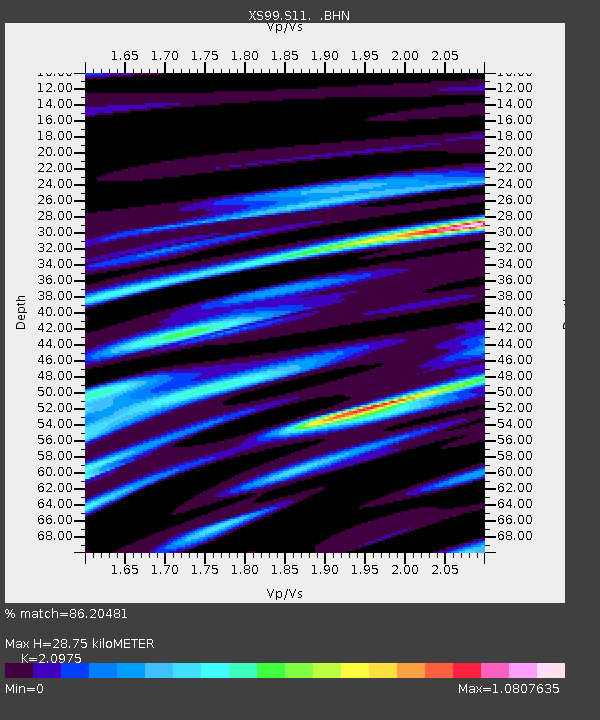
| Estimated Moho Depth: |
28.75 km |
| Estimated Crust Vp/Vs: |
2.10 |
| Assumed Crust Vp: |
6.242 km/s |
| Estimated Crust Vs: |
2.976 km/s |
| Estimated Crust Poisson's Ratio: |
0.35 |
|
| Radial Match: |
86.20481 % |
| Radial Bump: |
400 |
| Transverse Match: |
66.37243 % |
| Transverse Bump: |
400 |
| SOD ConfigId: |
16820 |
| Insert Time: |
2010-03-09 12:33:14.940 +0000 |
| GWidth: |
2.5 |
| Max Bumps: |
400 |
| Tol: |
0.001 |
|

Signal To Noise
| Channel | StoN | STA | LTA |
| XS:S11: :BHN:20000617T15:51:12.050013Z | 0.9801982 | 1.2852504E-6 | 1.3112149E-6 |
| XS:S11: :BHE:20000617T15:51:12.050013Z | 1.4173205 | 9.302953E-7 | 6.5637613E-7 |
| XS:S11: :BHZ:20000617T15:51:12.050013Z | 1.1072639 | 1.8334633E-6 | 1.6558504E-6 |
| Arrivals |
| Ps | 5.3 SECOND |
| PpPs | 14 SECOND |
| PsPs/PpSs | 19 SECOND |


