You are here: Home > Network List > IU - Global Seismograph Network (GSN - IRIS/USGS) Stations List
> Station PMG Port Moresby, New Guinea > Earthquake Result Viewer
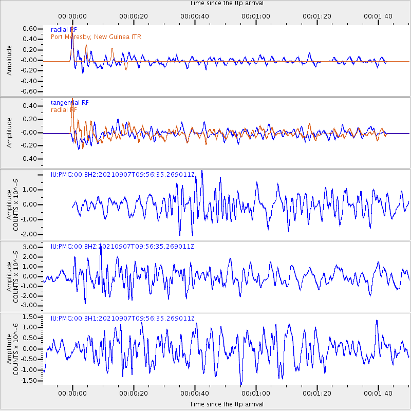
PMG Port Moresby, New Guinea - Earthquake Result Viewer
*The percent match for this event was below the threshold and hence no stack was calculated.
| Earthquake location: |
Fiji Islands Region |
| Earthquake latitude/longitude: |
-19.4/-176.1 |
| Earthquake time(UTC): |
2021/09/07 (250) 09:49:57 GMT |
| Earthquake Depth: |
10 km |
| Earthquake Magnitude: |
5.8 mww |
| Earthquake Catalog/Contributor: |
NEIC PDE/us |
|
| Network: |
IU Global Seismograph Network (GSN - IRIS/USGS) |
| Station: |
PMG Port Moresby, New Guinea |
| Lat/Lon: |
9.40 S/147.16 E |
| Elevation: |
90 m |
|
| Distance: |
36.9 deg |
| Az: |
280.341 deg |
| Baz: |
109.775 deg |
| Ray Param: |
$rayparam |
*The percent match for this event was below the threshold and hence was not used in the summary stack. |
|
| Radial Match: |
60.025227 % |
| Radial Bump: |
400 |
| Transverse Match: |
52.726765 % |
| Transverse Bump: |
400 |
| SOD ConfigId: |
25131211 |
| Insert Time: |
2021-09-21 10:04:07.715 +0000 |
| GWidth: |
2.5 |
| Max Bumps: |
400 |
| Tol: |
0.001 |
|
Signal To Noise
| Channel | StoN | STA | LTA |
| IU:PMG:00:BHZ:20210907T09:56:35.269011Z | 3.4438424 | 1.0934182E-6 | 3.1749948E-7 |
| IU:PMG:00:BH1:20210907T09:56:35.269011Z | 0.4844379 | 2.3712242E-7 | 4.894795E-7 |
| IU:PMG:00:BH2:20210907T09:56:35.269011Z | 1.6361572 | 6.4042354E-7 | 3.9141935E-7 |
| Arrivals |
| Ps | |
| PpPs | |
| PsPs/PpSs | |


