You are here: Home > Network List > IW - Intermountain West Stations List
> Station MOOW Moose Ponds, Wyoming, USA > Earthquake Result Viewer
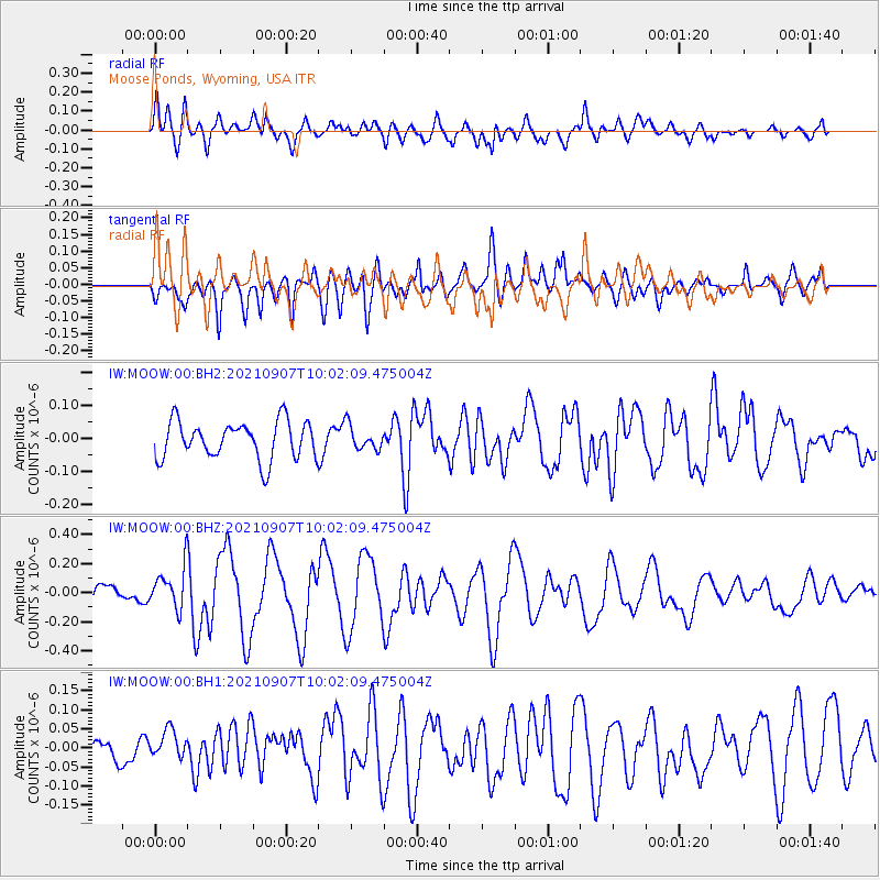
MOOW Moose Ponds, Wyoming, USA - Earthquake Result Viewer
*The percent match for this event was below the threshold and hence no stack was calculated.
| Earthquake location: |
Fiji Islands Region |
| Earthquake latitude/longitude: |
-19.4/-176.1 |
| Earthquake time(UTC): |
2021/09/07 (250) 09:49:57 GMT |
| Earthquake Depth: |
10 km |
| Earthquake Magnitude: |
5.8 mww |
| Earthquake Catalog/Contributor: |
NEIC PDE/us |
|
| Network: |
IW Intermountain West |
| Station: |
MOOW Moose Ponds, Wyoming, USA |
| Lat/Lon: |
43.75 N/110.74 W |
| Elevation: |
2128 m |
|
| Distance: |
86.7 deg |
| Az: |
41.268 deg |
| Baz: |
239.213 deg |
| Ray Param: |
$rayparam |
*The percent match for this event was below the threshold and hence was not used in the summary stack. |
|
| Radial Match: |
68.3088 % |
| Radial Bump: |
400 |
| Transverse Match: |
69.242516 % |
| Transverse Bump: |
400 |
| SOD ConfigId: |
25131211 |
| Insert Time: |
2021-09-21 10:04:21.845 +0000 |
| GWidth: |
2.5 |
| Max Bumps: |
400 |
| Tol: |
0.001 |
|
Signal To Noise
| Channel | StoN | STA | LTA |
| IW:MOOW:00:BHZ:20210907T10:02:09.475004Z | 1.7180798 | 1.4155496E-7 | 8.2391374E-8 |
| IW:MOOW:00:BH1:20210907T10:02:09.475004Z | 0.70379716 | 3.300703E-8 | 4.68985E-8 |
| IW:MOOW:00:BH2:20210907T10:02:09.475004Z | 0.63097537 | 3.5953487E-8 | 5.698081E-8 |
| Arrivals |
| Ps | |
| PpPs | |
| PsPs/PpSs | |


