You are here: Home > Network List > TA - USArray Transportable Network (new EarthScope stations) Stations List
> Station POKR Poker Plat Research Range, AK, USA > Earthquake Result Viewer
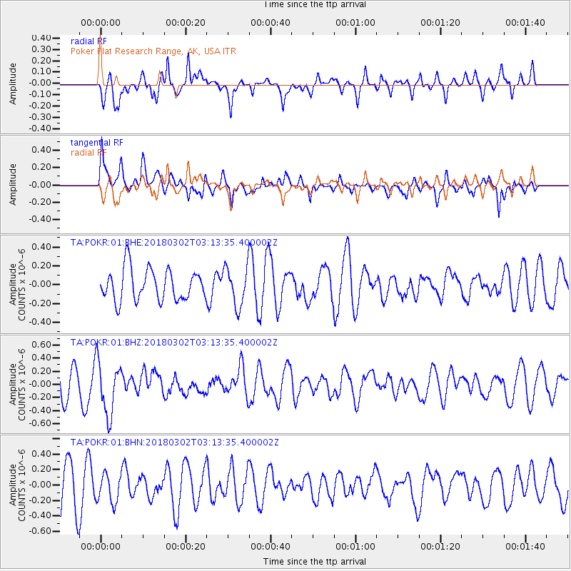
POKR Poker Plat Research Range, AK, USA - Earthquake Result Viewer
*The percent match for this event was below the threshold and hence no stack was calculated.
| Earthquake location: |
New Guinea, Papua New Guinea |
| Earthquake latitude/longitude: |
-6.1/142.5 |
| Earthquake time(UTC): |
2018/03/02 (061) 03:01:23 GMT |
| Earthquake Depth: |
29 km |
| Earthquake Magnitude: |
5.6 Mww |
| Earthquake Catalog/Contributor: |
NEIC PDE/us |
|
| Network: |
TA USArray Transportable Network (new EarthScope stations) |
| Station: |
POKR Poker Plat Research Range, AK, USA |
| Lat/Lon: |
65.12 N/147.43 W |
| Elevation: |
501 m |
|
| Distance: |
87.2 deg |
| Az: |
23.462 deg |
| Baz: |
249.362 deg |
| Ray Param: |
$rayparam |
*The percent match for this event was below the threshold and hence was not used in the summary stack. |
|
| Radial Match: |
45.58387 % |
| Radial Bump: |
400 |
| Transverse Match: |
62.48884 % |
| Transverse Bump: |
400 |
| SOD ConfigId: |
2615551 |
| Insert Time: |
2018-03-16 03:02:42.908 +0000 |
| GWidth: |
2.5 |
| Max Bumps: |
400 |
| Tol: |
0.001 |
|
Signal To Noise
| Channel | StoN | STA | LTA |
| TA:POKR:01:BHZ:20180302T03:13:35.400002Z | 1.9945284 | 4.0780165E-7 | 2.0446019E-7 |
| TA:POKR:01:BHN:20180302T03:13:35.400002Z | 0.63391525 | 1.8273953E-7 | 2.8827122E-7 |
| TA:POKR:01:BHE:20180302T03:13:35.400002Z | 1.2748916 | 2.1162161E-7 | 1.6599185E-7 |
| Arrivals |
| Ps | |
| PpPs | |
| PsPs/PpSs | |


