You are here: Home > Network List > PY - PFO Array Stations List
> Station BPH08 Pinon Flat Observatory, CA, USA > Earthquake Result Viewer
BPH08 Pinon Flat Observatory, CA, USA - Earthquake Result Viewer
| Earthquake location: |
Fiji Islands Region |
| Earthquake latitude/longitude: |
-19.4/-176.1 |
| Earthquake time(UTC): |
2021/09/07 (250) 09:49:57 GMT |
| Earthquake Depth: |
10 km |
| Earthquake Magnitude: |
5.8 mww |
| Earthquake Catalog/Contributor: |
NEIC PDE/us |
|
| Network: |
PY PFO Array |
| Station: |
BPH08 Pinon Flat Observatory, CA, USA |
| Lat/Lon: |
33.61 N/116.46 W |
| Elevation: |
1300 m |
|
| Distance: |
77.5 deg |
| Az: |
47.502 deg |
| Baz: |
236.503 deg |
| Ray Param: |
0.050293636 |
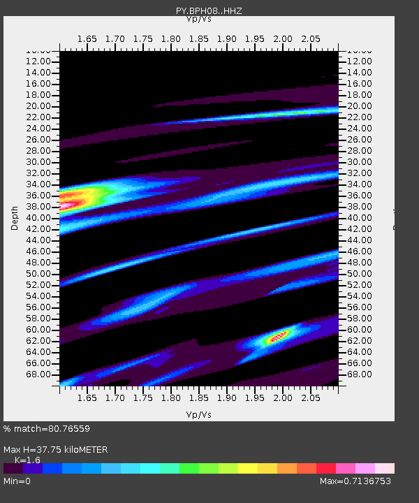
| Estimated Moho Depth: |
37.75 km |
| Estimated Crust Vp/Vs: |
1.60 |
| Assumed Crust Vp: |
6.264 km/s |
| Estimated Crust Vs: |
3.915 km/s |
| Estimated Crust Poisson's Ratio: |
0.18 |
|
| Radial Match: |
80.76559 % |
| Radial Bump: |
400 |
| Transverse Match: |
61.310734 % |
| Transverse Bump: |
400 |
| SOD ConfigId: |
25131211 |
| Insert Time: |
2021-09-21 10:08:52.658 +0000 |
| GWidth: |
2.5 |
| Max Bumps: |
400 |
| Tol: |
0.001 |
|

Signal To Noise
| Channel | StoN | STA | LTA |
| PY:BPH08: :HHZ:20210907T10:01:21.496Z | 2.4264088 | 2.4846284E-7 | 1.0239942E-7 |
| PY:BPH08: :HHN:20210907T10:01:21.496Z | 0.99901307 | 1.0350807E-7 | 1.03610326E-7 |
| PY:BPH08: :HHE:20210907T10:01:21.496Z | 0.9106015 | 1.4078671E-7 | 1.5460847E-7 |
| Arrivals |
| Ps | 3.7 SECOND |
| PpPs | 15 SECOND |
| PsPs/PpSs | 19 SECOND |


