You are here: Home > Network List > TX - Texas Seismological Network Stations List
> Station WTFS Witchita Falls > Earthquake Result Viewer
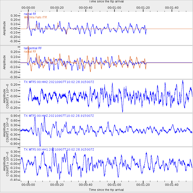
WTFS Witchita Falls - Earthquake Result Viewer
*The percent match for this event was below the threshold and hence no stack was calculated.
| Earthquake location: |
Fiji Islands Region |
| Earthquake latitude/longitude: |
-19.4/-176.1 |
| Earthquake time(UTC): |
2021/09/07 (250) 09:49:57 GMT |
| Earthquake Depth: |
10 km |
| Earthquake Magnitude: |
5.8 mww |
| Earthquake Catalog/Contributor: |
NEIC PDE/us |
|
| Network: |
TX Texas Seismological Network |
| Station: |
WTFS Witchita Falls |
| Lat/Lon: |
33.77 N/98.46 W |
| Elevation: |
277 m |
|
| Distance: |
90.8 deg |
| Az: |
54.455 deg |
| Baz: |
247.21 deg |
| Ray Param: |
$rayparam |
*The percent match for this event was below the threshold and hence was not used in the summary stack. |
|
| Radial Match: |
73.32439 % |
| Radial Bump: |
400 |
| Transverse Match: |
65.891815 % |
| Transverse Bump: |
400 |
| SOD ConfigId: |
25131211 |
| Insert Time: |
2021-09-21 10:11:33.073 +0000 |
| GWidth: |
2.5 |
| Max Bumps: |
400 |
| Tol: |
0.001 |
|
Signal To Noise
| Channel | StoN | STA | LTA |
| TX:WTFS:00:HHZ:20210907T10:02:28.915007Z | 3.975854 | 2.673969E-7 | 6.725521E-8 |
| TX:WTFS:00:HH1:20210907T10:02:28.915007Z | 0.81328076 | 6.789906E-8 | 8.348784E-8 |
| TX:WTFS:00:HH2:20210907T10:02:28.915007Z | 0.888178 | 5.3057228E-8 | 5.9737154E-8 |
| Arrivals |
| Ps | |
| PpPs | |
| PsPs/PpSs | |


