You are here: Home > Network List > US - United States National Seismic Network Stations List
> Station EGMT Eagleton, Montana, USA > Earthquake Result Viewer
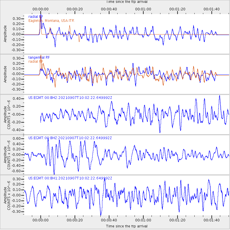
EGMT Eagleton, Montana, USA - Earthquake Result Viewer
*The percent match for this event was below the threshold and hence no stack was calculated.
| Earthquake location: |
Fiji Islands Region |
| Earthquake latitude/longitude: |
-19.4/-176.1 |
| Earthquake time(UTC): |
2021/09/07 (250) 09:49:57 GMT |
| Earthquake Depth: |
10 km |
| Earthquake Magnitude: |
5.8 mww |
| Earthquake Catalog/Contributor: |
NEIC PDE/us |
|
| Network: |
US United States National Seismic Network |
| Station: |
EGMT Eagleton, Montana, USA |
| Lat/Lon: |
48.02 N/109.75 W |
| Elevation: |
1055 m |
|
| Distance: |
89.4 deg |
| Az: |
37.933 deg |
| Baz: |
239.808 deg |
| Ray Param: |
$rayparam |
*The percent match for this event was below the threshold and hence was not used in the summary stack. |
|
| Radial Match: |
58.921295 % |
| Radial Bump: |
400 |
| Transverse Match: |
57.360653 % |
| Transverse Bump: |
400 |
| SOD ConfigId: |
25131211 |
| Insert Time: |
2021-09-21 10:12:22.182 +0000 |
| GWidth: |
2.5 |
| Max Bumps: |
400 |
| Tol: |
0.001 |
|
Signal To Noise
| Channel | StoN | STA | LTA |
| US:EGMT:00:BHZ:20210907T10:02:22.649992Z | 2.8044107 | 2.2988691E-7 | 8.197334E-8 |
| US:EGMT:00:BH1:20210907T10:02:22.649992Z | 0.769918 | 8.6196145E-8 | 1.1195497E-7 |
| US:EGMT:00:BH2:20210907T10:02:22.649992Z | 1.5801754 | 1.2056786E-7 | 7.63003E-8 |
| Arrivals |
| Ps | |
| PpPs | |
| PsPs/PpSs | |


