You are here: Home > Network List > 1E - GSC-BCOGC Induced Seismicity Study Stations List
> Station BCH1A Z > Earthquake Result Viewer
BCH1A Z - Earthquake Result Viewer
| Earthquake location: |
Near Coast Of Guerrero, Mexico |
| Earthquake latitude/longitude: |
17.0/-99.8 |
| Earthquake time(UTC): |
2021/09/08 (251) 01:47:46 GMT |
| Earthquake Depth: |
13 km |
| Earthquake Magnitude: |
7.0 mww |
| Earthquake Catalog/Contributor: |
NEIC PDE/us |
|
| Network: |
1E GSC-BCOGC Induced Seismicity Study |
| Station: |
BCH1A Z |
| Lat/Lon: |
55.83 N/120.26 W |
| Elevation: |
689 m |
|
| Distance: |
41.8 deg |
| Az: |
342.79 deg |
| Baz: |
149.874 deg |
| Ray Param: |
0.07353859 |
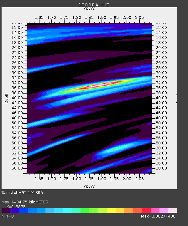
| Estimated Moho Depth: |
34.75 km |
| Estimated Crust Vp/Vs: |
1.89 |
| Assumed Crust Vp: |
6.303 km/s |
| Estimated Crust Vs: |
3.339 km/s |
| Estimated Crust Poisson's Ratio: |
0.30 |
|
| Radial Match: |
92.191895 % |
| Radial Bump: |
341 |
| Transverse Match: |
72.57583 % |
| Transverse Bump: |
400 |
| SOD ConfigId: |
25131211 |
| Insert Time: |
2021-09-22 01:48:09.155 +0000 |
| GWidth: |
2.5 |
| Max Bumps: |
400 |
| Tol: |
0.001 |
|

Signal To Noise
| Channel | StoN | STA | LTA |
| 1E:BCH1A: :HHZ:20210908T01:55:05.499992Z | 23.390175 | 7.382109E-6 | 3.1560725E-7 |
| 1E:BCH1A: :HHN:20210908T01:55:05.499992Z | 11.737527 | 3.7656328E-6 | 3.2081994E-7 |
| 1E:BCH1A: :HHE:20210908T01:55:05.499992Z | 12.570444 | 2.9487296E-6 | 2.345764E-7 |
| Arrivals |
| Ps | 5.2 SECOND |
| PpPs | 15 SECOND |
| PsPs/PpSs | 20 SECOND |


