You are here: Home > Network List > 1E - GSC-BCOGC Induced Seismicity Study Stations List
> Station BCH2A Z > Earthquake Result Viewer
BCH2A Z - Earthquake Result Viewer
| Earthquake location: |
Near Coast Of Guerrero, Mexico |
| Earthquake latitude/longitude: |
17.0/-99.8 |
| Earthquake time(UTC): |
2021/09/08 (251) 01:47:46 GMT |
| Earthquake Depth: |
13 km |
| Earthquake Magnitude: |
7.0 mww |
| Earthquake Catalog/Contributor: |
NEIC PDE/us |
|
| Network: |
1E GSC-BCOGC Induced Seismicity Study |
| Station: |
BCH2A Z |
| Lat/Lon: |
55.95 N/120.36 W |
| Elevation: |
761 m |
|
| Distance: |
42.0 deg |
| Az: |
342.805 deg |
| Baz: |
149.805 deg |
| Ray Param: |
0.073457204 |
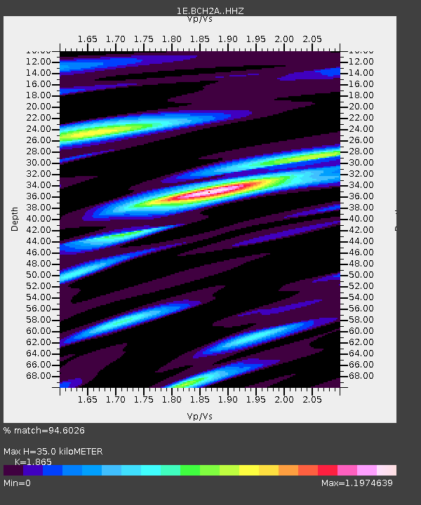
| Estimated Moho Depth: |
35.0 km |
| Estimated Crust Vp/Vs: |
1.87 |
| Assumed Crust Vp: |
6.303 km/s |
| Estimated Crust Vs: |
3.379 km/s |
| Estimated Crust Poisson's Ratio: |
0.30 |
|
| Radial Match: |
94.6026 % |
| Radial Bump: |
400 |
| Transverse Match: |
81.51069 % |
| Transverse Bump: |
400 |
| SOD ConfigId: |
25131211 |
| Insert Time: |
2021-09-22 01:48:09.318 +0000 |
| GWidth: |
2.5 |
| Max Bumps: |
400 |
| Tol: |
0.001 |
|

Signal To Noise
| Channel | StoN | STA | LTA |
| 1E:BCH2A: :HHZ:20210908T01:55:06.529991Z | 34.781105 | 7.2754474E-6 | 2.0917815E-7 |
| 1E:BCH2A: :HHN:20210908T01:55:06.529991Z | 10.599859 | 3.3457395E-6 | 3.1564E-7 |
| 1E:BCH2A: :HHE:20210908T01:55:06.529991Z | 11.275247 | 3.3984766E-6 | 3.0141038E-7 |
| Arrivals |
| Ps | 5.1 SECOND |
| PpPs | 15 SECOND |
| PsPs/PpSs | 20 SECOND |


