You are here: Home > Network List > AK - Alaska Regional Network Stations List
> Station COLD Coldfoot Broadband > Earthquake Result Viewer
COLD Coldfoot Broadband - Earthquake Result Viewer

| Earthquake location: |
Near Coast Of Guerrero, Mexico |
| Earthquake latitude/longitude: |
17.0/-99.8 |
| Earthquake time(UTC): |
2021/09/08 (251) 01:47:46 GMT |
| Earthquake Depth: |
13 km |
| Earthquake Magnitude: |
7.0 mww |
| Earthquake Catalog/Contributor: |
NEIC PDE/us |
|
| Network: |
AK Alaska Regional Network |
| Station: |
COLD Coldfoot Broadband |
| Lat/Lon: |
67.23 N/150.20 W |
| Elevation: |
377 m |
|
| Distance: |
59.7 deg |
| Az: |
339.67 deg |
| Baz: |
121.33 deg |
| Ray Param: |
0.062002305 |
| Estimated Moho Depth: |
39.25 km |
| Estimated Crust Vp/Vs: |
1.71 |
| Assumed Crust Vp: |
6.577 km/s |
| Estimated Crust Vs: |
3.852 km/s |
| Estimated Crust Poisson's Ratio: |
0.24 |
|
| Radial Match: |
97.85183 % |
| Radial Bump: |
219 |
| Transverse Match: |
83.88589 % |
| Transverse Bump: |
400 |
| SOD ConfigId: |
25131211 |
| Insert Time: |
2021-09-22 01:49:07.882 +0000 |
| GWidth: |
2.5 |
| Max Bumps: |
400 |
| Tol: |
0.001 |
|
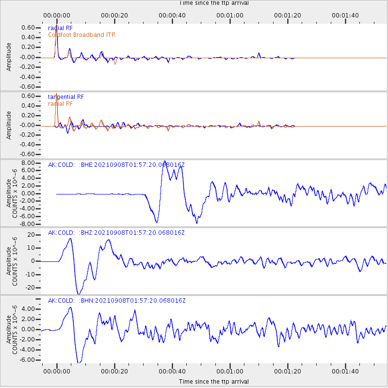
Signal To Noise
| Channel | StoN | STA | LTA |
| AK:COLD: :BHZ:20210908T01:57:20.068016Z | 158.4329 | 9.274411E-6 | 5.8538415E-8 |
| AK:COLD: :BHN:20210908T01:57:20.068016Z | 53.560684 | 2.3151904E-6 | 4.3225555E-8 |
| AK:COLD: :BHE:20210908T01:57:20.068016Z | 92.59401 | 3.7866712E-6 | 4.0895426E-8 |
| Arrivals |
| Ps | 4.4 SECOND |
| PpPs | 15 SECOND |
| PsPs/PpSs | 20 SECOND |


