You are here: Home > Network List > AK - Alaska Regional Network Stations List
> Station M19K Big River Lodge, Big River, AK, USA > Earthquake Result Viewer
M19K Big River Lodge, Big River, AK, USA - Earthquake Result Viewer
| Earthquake location: |
Near Coast Of Guerrero, Mexico |
| Earthquake latitude/longitude: |
17.0/-99.8 |
| Earthquake time(UTC): |
2021/09/08 (251) 01:47:46 GMT |
| Earthquake Depth: |
13 km |
| Earthquake Magnitude: |
7.0 mww |
| Earthquake Catalog/Contributor: |
NEIC PDE/us |
|
| Network: |
AK Alaska Regional Network |
| Station: |
M19K Big River Lodge, Big River, AK, USA |
| Lat/Lon: |
61.90 N/154.39 W |
| Elevation: |
521 m |
|
| Distance: |
58.8 deg |
| Az: |
333.188 deg |
| Baz: |
114.231 deg |
| Ray Param: |
0.06258665 |
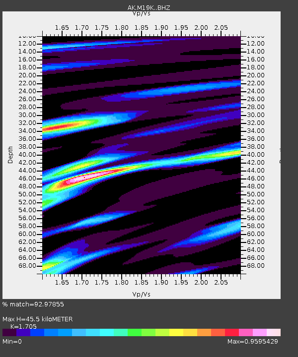
| Estimated Moho Depth: |
45.5 km |
| Estimated Crust Vp/Vs: |
1.71 |
| Assumed Crust Vp: |
6.566 km/s |
| Estimated Crust Vs: |
3.851 km/s |
| Estimated Crust Poisson's Ratio: |
0.24 |
|
| Radial Match: |
92.97855 % |
| Radial Bump: |
400 |
| Transverse Match: |
84.42709 % |
| Transverse Bump: |
400 |
| SOD ConfigId: |
25131211 |
| Insert Time: |
2021-09-22 01:50:56.488 +0000 |
| GWidth: |
2.5 |
| Max Bumps: |
400 |
| Tol: |
0.001 |
|

Signal To Noise
| Channel | StoN | STA | LTA |
| AK:M19K: :BHZ:20210908T01:57:13.899986Z | 147.45674 | 9.968843E-6 | 6.760521E-8 |
| AK:M19K: :BHN:20210908T01:57:13.899986Z | 30.17409 | 1.827562E-6 | 6.056726E-8 |
| AK:M19K: :BHE:20210908T01:57:13.899986Z | 95.10903 | 4.1108788E-6 | 4.3222798E-8 |
| Arrivals |
| Ps | 5.1 SECOND |
| PpPs | 18 SECOND |
| PsPs/PpSs | 23 SECOND |


