You are here: Home > Network List > AK - Alaska Regional Network Stations List
> Station R16K Pilot Point, AK, USA > Earthquake Result Viewer
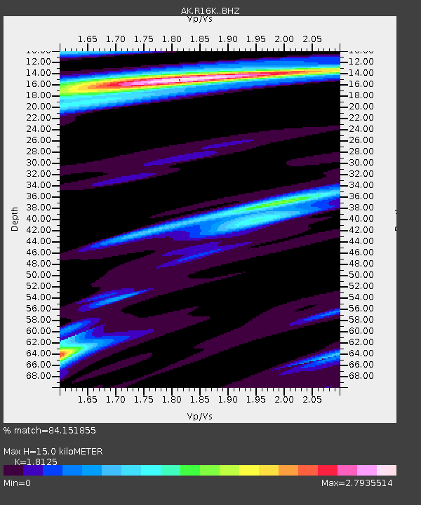
R16K Pilot Point, AK, USA - Earthquake Result Viewer
| Earthquake location: |
Near Coast Of Guerrero, Mexico |
| Earthquake latitude/longitude: |
17.0/-99.8 |
| Earthquake time(UTC): |
2021/09/08 (251) 01:47:46 GMT |
| Earthquake Depth: |
13 km |
| Earthquake Magnitude: |
7.0 mww |
| Earthquake Catalog/Contributor: |
NEIC PDE/us |
|
| Network: |
AK Alaska Regional Network |
| Station: |
R16K Pilot Point, AK, USA |
| Lat/Lon: |
57.57 N/157.57 W |
| Elevation: |
38 m |
|
| Distance: |
58.7 deg |
| Az: |
327.765 deg |
| Baz: |
108.672 deg |
| Ray Param: |
0.062642746 |
| Estimated Moho Depth: |
15.0 km |
| Estimated Crust Vp/Vs: |
1.81 |
| Assumed Crust Vp: |
6.1 km/s |
| Estimated Crust Vs: |
3.366 km/s |
| Estimated Crust Poisson's Ratio: |
0.28 |
|
| Radial Match: |
84.151855 % |
| Radial Bump: |
400 |
| Transverse Match: |
59.861034 % |
| Transverse Bump: |
400 |
| SOD ConfigId: |
25131211 |
| Insert Time: |
2021-09-22 01:51:46.833 +0000 |
| GWidth: |
2.5 |
| Max Bumps: |
400 |
| Tol: |
0.001 |
|

Signal To Noise
| Channel | StoN | STA | LTA |
| AK:R16K: :BHZ:20210908T01:57:13.279991Z | 13.925256 | 9.045758E-6 | 6.495937E-7 |
| AK:R16K: :BHN:20210908T01:57:13.279991Z | 2.915466 | 1.5274167E-6 | 5.2390135E-7 |
| AK:R16K: :BHE:20210908T01:57:13.279991Z | 9.0247755 | 4.7141925E-6 | 5.223612E-7 |
| Arrivals |
| Ps | 2.1 SECOND |
| PpPs | 6.6 SECOND |
| PsPs/PpSs | 8.7 SECOND |


