You are here: Home > Network List > AK - Alaska Regional Network Stations List
> Station WAX Waxell Ridge, AK, USA > Earthquake Result Viewer
WAX Waxell Ridge, AK, USA - Earthquake Result Viewer
| Earthquake location: |
Near Coast Of Guerrero, Mexico |
| Earthquake latitude/longitude: |
17.0/-99.8 |
| Earthquake time(UTC): |
2021/09/08 (251) 01:47:46 GMT |
| Earthquake Depth: |
13 km |
| Earthquake Magnitude: |
7.0 mww |
| Earthquake Catalog/Contributor: |
NEIC PDE/us |
|
| Network: |
AK Alaska Regional Network |
| Station: |
WAX Waxell Ridge, AK, USA |
| Lat/Lon: |
60.45 N/142.85 W |
| Elevation: |
1003 m |
|
| Distance: |
53.3 deg |
| Az: |
335.013 deg |
| Baz: |
125.355 deg |
| Ray Param: |
0.06623112 |
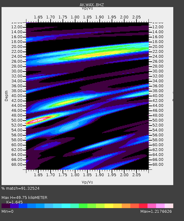
| Estimated Moho Depth: |
49.75 km |
| Estimated Crust Vp/Vs: |
1.64 |
| Assumed Crust Vp: |
6.566 km/s |
| Estimated Crust Vs: |
3.992 km/s |
| Estimated Crust Poisson's Ratio: |
0.21 |
|
| Radial Match: |
91.32524 % |
| Radial Bump: |
400 |
| Transverse Match: |
81.33764 % |
| Transverse Bump: |
400 |
| SOD ConfigId: |
25131211 |
| Insert Time: |
2021-09-22 01:52:33.189 +0000 |
| GWidth: |
2.5 |
| Max Bumps: |
400 |
| Tol: |
0.001 |
|

Signal To Noise
| Channel | StoN | STA | LTA |
| AK:WAX: :BHZ:20210908T01:56:34.147972Z | 59.131775 | 7.300706E-6 | 1.2346501E-7 |
| AK:WAX: :BHN:20210908T01:56:34.147972Z | 6.701334 | 1.9631934E-6 | 2.9295563E-7 |
| AK:WAX: :BHE:20210908T01:56:34.147972Z | 16.970123 | 2.8129505E-6 | 1.6575899E-7 |
| Arrivals |
| Ps | 5.2 SECOND |
| PpPs | 19 SECOND |
| PsPs/PpSs | 24 SECOND |


