You are here: Home > Network List > AV - Alaska Volcano Observatory Stations List
> Station AUCH Augustine Cone H, Augustine Volcano, Alaska > Earthquake Result Viewer
AUCH Augustine Cone H, Augustine Volcano, Alaska - Earthquake Result Viewer
| Earthquake location: |
Near Coast Of Guerrero, Mexico |
| Earthquake latitude/longitude: |
17.0/-99.8 |
| Earthquake time(UTC): |
2021/09/08 (251) 01:47:46 GMT |
| Earthquake Depth: |
13 km |
| Earthquake Magnitude: |
7.0 mww |
| Earthquake Catalog/Contributor: |
NEIC PDE/us |
|
| Network: |
AV Alaska Volcano Observatory |
| Station: |
AUCH Augustine Cone H, Augustine Volcano, Alaska |
| Lat/Lon: |
59.36 N/153.44 W |
| Elevation: |
916 m |
|
| Distance: |
57.4 deg |
| Az: |
330.667 deg |
| Baz: |
113.722 deg |
| Ray Param: |
0.06354217 |
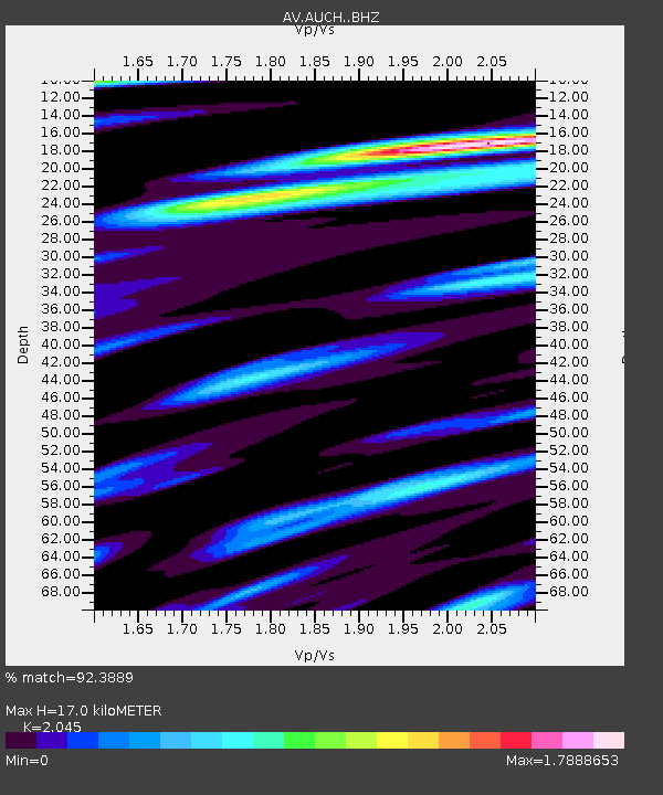
| Estimated Moho Depth: |
17.0 km |
| Estimated Crust Vp/Vs: |
2.05 |
| Assumed Crust Vp: |
5.989 km/s |
| Estimated Crust Vs: |
2.929 km/s |
| Estimated Crust Poisson's Ratio: |
0.34 |
|
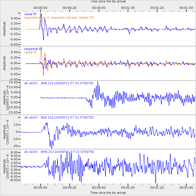
| Radial Match: |
92.3889 % |
| Radial Bump: |
400 |
| Transverse Match: |
74.35115 % |
| Transverse Bump: |
400 |
| SOD ConfigId: |
25131211 |
| Insert Time: |
2021-09-22 01:53:04.689 +0000 |
| GWidth: |
2.5 |
| Max Bumps: |
400 |
| Tol: |
0.001 |
|
Signal To Noise
| Channel | StoN | STA | LTA |
| AV:AUCH: :BHZ:20210908T01:57:03.678978Z | 59.036392 | 6.9130087E-6 | 1.17097414E-7 |
| AV:AUCH: :BHN:20210908T01:57:03.678978Z | 5.4667706 | 1.2808802E-6 | 2.3430289E-7 |
| AV:AUCH: :BHE:20210908T01:57:03.678978Z | 18.271015 | 2.820567E-6 | 1.5437385E-7 |
| Arrivals |
| Ps | 3.1 SECOND |
| PpPs | 8.3 SECOND |
| PsPs/PpSs | 11 SECOND |


