You are here: Home > Network List > AV - Alaska Volcano Observatory Stations List
> Station AUJA Augustine Junction, Augustine Volcano, Alaska > Earthquake Result Viewer
AUJA Augustine Junction, Augustine Volcano, Alaska - Earthquake Result Viewer

| Earthquake location: |
Near Coast Of Guerrero, Mexico |
| Earthquake latitude/longitude: |
17.0/-99.8 |
| Earthquake time(UTC): |
2021/09/08 (251) 01:47:46 GMT |
| Earthquake Depth: |
13 km |
| Earthquake Magnitude: |
7.0 mww |
| Earthquake Catalog/Contributor: |
NEIC PDE/us |
|
| Network: |
AV Alaska Volcano Observatory |
| Station: |
AUJA Augustine Junction, Augustine Volcano, Alaska |
| Lat/Lon: |
59.34 N/153.42 W |
| Elevation: |
376 m |
|
| Distance: |
57.3 deg |
| Az: |
330.647 deg |
| Baz: |
113.73 deg |
| Ray Param: |
0.06355449 |
| Estimated Moho Depth: |
20.5 km |
| Estimated Crust Vp/Vs: |
1.65 |
| Assumed Crust Vp: |
5.989 km/s |
| Estimated Crust Vs: |
3.635 km/s |
| Estimated Crust Poisson's Ratio: |
0.21 |
|
| Radial Match: |
93.373726 % |
| Radial Bump: |
400 |
| Transverse Match: |
75.83819 % |
| Transverse Bump: |
400 |
| SOD ConfigId: |
25131211 |
| Insert Time: |
2021-09-22 01:53:06.573 +0000 |
| GWidth: |
2.5 |
| Max Bumps: |
400 |
| Tol: |
0.001 |
|
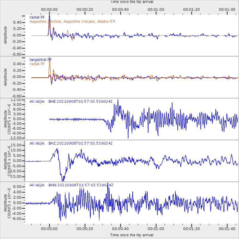
Signal To Noise
| Channel | StoN | STA | LTA |
| AV:AUJA: :BHZ:20210908T01:57:03.539024Z | 104.198494 | 6.516193E-6 | 6.2536344E-8 |
| AV:AUJA: :BHN:20210908T01:57:03.539024Z | 11.905167 | 1.4527311E-6 | 1.2202526E-7 |
| AV:AUJA: :BHE:20210908T01:57:03.539024Z | 13.121458 | 3.0794345E-6 | 2.3468691E-7 |
| Arrivals |
| Ps | 2.3 SECOND |
| PpPs | 8.7 SECOND |
| PsPs/PpSs | 11 SECOND |


