You are here: Home > Network List > AV - Alaska Volcano Observatory Stations List
> Station AUJK Augustine Jurgen Kienle, Cook Inlet, Alaska > Earthquake Result Viewer
AUJK Augustine Jurgen Kienle, Cook Inlet, Alaska - Earthquake Result Viewer
| Earthquake location: |
Near Coast Of Guerrero, Mexico |
| Earthquake latitude/longitude: |
17.0/-99.8 |
| Earthquake time(UTC): |
2021/09/08 (251) 01:47:46 GMT |
| Earthquake Depth: |
13 km |
| Earthquake Magnitude: |
7.0 mww |
| Earthquake Catalog/Contributor: |
NEIC PDE/us |
|
| Network: |
AV Alaska Volcano Observatory |
| Station: |
AUJK Augustine Jurgen Kienle, Cook Inlet, Alaska |
| Lat/Lon: |
59.35 N/153.41 W |
| Elevation: |
377 m |
|
| Distance: |
57.3 deg |
| Az: |
330.661 deg |
| Baz: |
113.748 deg |
| Ray Param: |
0.06355556 |
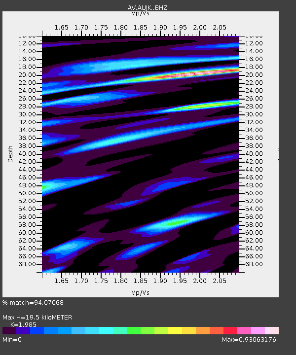
| Estimated Moho Depth: |
19.5 km |
| Estimated Crust Vp/Vs: |
1.99 |
| Assumed Crust Vp: |
5.989 km/s |
| Estimated Crust Vs: |
3.017 km/s |
| Estimated Crust Poisson's Ratio: |
0.33 |
|
| Radial Match: |
94.07068 % |
| Radial Bump: |
400 |
| Transverse Match: |
62.872288 % |
| Transverse Bump: |
400 |
| SOD ConfigId: |
25131211 |
| Insert Time: |
2021-09-22 01:53:07.579 +0000 |
| GWidth: |
2.5 |
| Max Bumps: |
400 |
| Tol: |
0.001 |
|

Signal To Noise
| Channel | StoN | STA | LTA |
| AV:AUJK: :BHZ:20210908T01:57:03.519981Z | 89.89074 | 1.0325782E-5 | 1.1487036E-7 |
| AV:AUJK: :BHN:20210908T01:57:03.519981Z | 7.255989 | 1.9435884E-6 | 2.678599E-7 |
| AV:AUJK: :BHE:20210908T01:57:03.519981Z | 17.691128 | 4.5246916E-6 | 2.5576048E-7 |
| Arrivals |
| Ps | 3.3 SECOND |
| PpPs | 9.4 SECOND |
| PsPs/PpSs | 13 SECOND |


