You are here: Home > Network List > AV - Alaska Volcano Observatory Stations List
> Station BOGO Bogoslof, Bogoslof Volcano, Alaska > Earthquake Result Viewer
BOGO Bogoslof, Bogoslof Volcano, Alaska - Earthquake Result Viewer
| Earthquake location: |
Near Coast Of Guerrero, Mexico |
| Earthquake latitude/longitude: |
17.0/-99.8 |
| Earthquake time(UTC): |
2021/09/08 (251) 01:47:46 GMT |
| Earthquake Depth: |
13 km |
| Earthquake Magnitude: |
7.0 mww |
| Earthquake Catalog/Contributor: |
NEIC PDE/us |
|
| Network: |
AV Alaska Volcano Observatory |
| Station: |
BOGO Bogoslof, Bogoslof Volcano, Alaska |
| Lat/Lon: |
53.93 N/168.03 W |
| Elevation: |
5.0 m |
|
| Distance: |
63.7 deg |
| Az: |
322.208 deg |
| Baz: |
97.351 deg |
| Ray Param: |
0.059416495 |
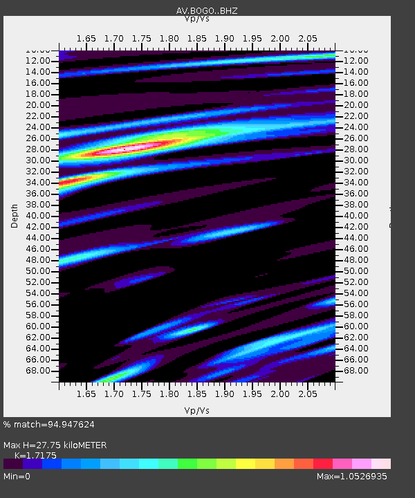
| Estimated Moho Depth: |
27.75 km |
| Estimated Crust Vp/Vs: |
1.72 |
| Assumed Crust Vp: |
5.88 km/s |
| Estimated Crust Vs: |
3.424 km/s |
| Estimated Crust Poisson's Ratio: |
0.24 |
|
| Radial Match: |
94.947624 % |
| Radial Bump: |
399 |
| Transverse Match: |
77.46723 % |
| Transverse Bump: |
400 |
| SOD ConfigId: |
25131211 |
| Insert Time: |
2021-09-22 01:53:16.594 +0000 |
| GWidth: |
2.5 |
| Max Bumps: |
400 |
| Tol: |
0.001 |
|

Signal To Noise
| Channel | StoN | STA | LTA |
| AV:BOGO: :BHZ:20210908T01:57:46.719017Z | 27.909513 | 5.3383383E-6 | 1.9127307E-7 |
| AV:BOGO: :BHN:20210908T01:57:46.719017Z | 1.876554 | 5.301716E-7 | 2.8252404E-7 |
| AV:BOGO: :BHE:20210908T01:57:46.719017Z | 10.650322 | 2.9807077E-6 | 2.798702E-7 |
| Arrivals |
| Ps | 3.5 SECOND |
| PpPs | 12 SECOND |
| PsPs/PpSs | 16 SECOND |


