You are here: Home > Network List > AV - Alaska Volcano Observatory Stations List
> Station CEAP Anvil Peak, Cerberus Volcano, Alaska > Earthquake Result Viewer
CEAP Anvil Peak, Cerberus Volcano, Alaska - Earthquake Result Viewer
| Earthquake location: |
Near Coast Of Guerrero, Mexico |
| Earthquake latitude/longitude: |
17.0/-99.8 |
| Earthquake time(UTC): |
2021/09/08 (251) 01:47:46 GMT |
| Earthquake Depth: |
13 km |
| Earthquake Magnitude: |
7.0 mww |
| Earthquake Catalog/Contributor: |
NEIC PDE/us |
|
| Network: |
AV Alaska Volcano Observatory |
| Station: |
CEAP Anvil Peak, Cerberus Volcano, Alaska |
| Lat/Lon: |
52.00 N/179.58 E |
| Elevation: |
244 m |
|
| Distance: |
71.1 deg |
| Az: |
319.852 deg |
| Baz: |
86.562 deg |
| Ray Param: |
0.05454394 |
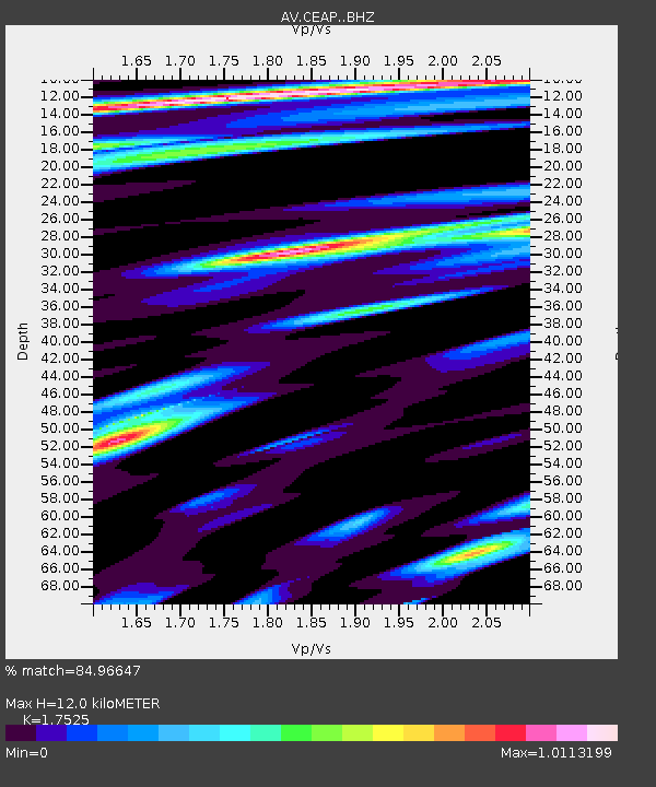
| Estimated Moho Depth: |
12.0 km |
| Estimated Crust Vp/Vs: |
1.75 |
| Assumed Crust Vp: |
6.183 km/s |
| Estimated Crust Vs: |
3.528 km/s |
| Estimated Crust Poisson's Ratio: |
0.26 |
|
| Radial Match: |
84.96647 % |
| Radial Bump: |
400 |
| Transverse Match: |
78.96695 % |
| Transverse Bump: |
400 |
| SOD ConfigId: |
25131211 |
| Insert Time: |
2021-09-22 01:53:19.715 +0000 |
| GWidth: |
2.5 |
| Max Bumps: |
400 |
| Tol: |
0.001 |
|
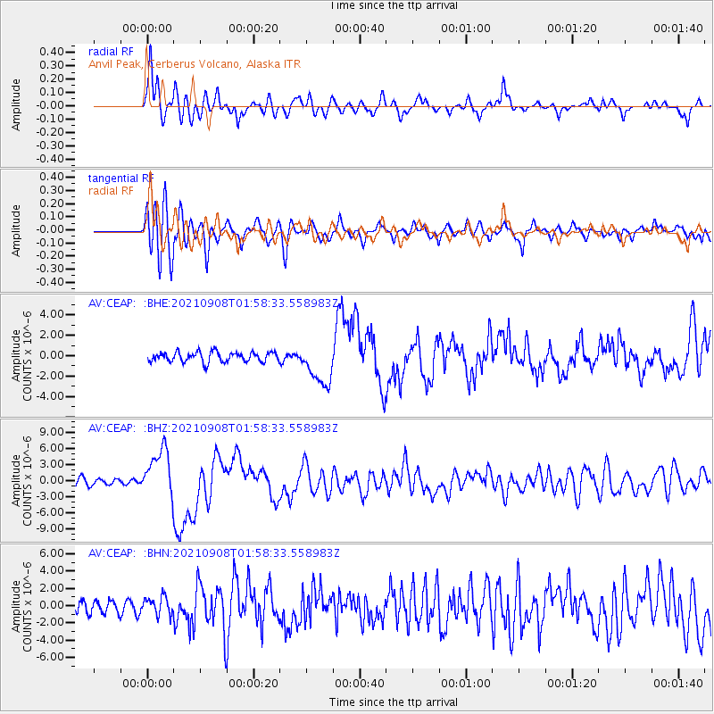
Signal To Noise
| Channel | StoN | STA | LTA |
| AV:CEAP: :BHZ:20210908T01:58:33.558983Z | 7.3825517 | 4.5944244E-6 | 6.2233556E-7 |
| AV:CEAP: :BHN:20210908T01:58:33.558983Z | 1.584678 | 1.0685507E-6 | 6.743015E-7 |
| AV:CEAP: :BHE:20210908T01:58:33.558983Z | 4.270364 | 2.0701336E-6 | 4.847675E-7 |
| Arrivals |
| Ps | 1.5 SECOND |
| PpPs | 5.2 SECOND |
| PsPs/PpSs | 6.7 SECOND |


