You are here: Home > Network List > AV - Alaska Volcano Observatory Stations List
> Station GSIG Igitkin Island, Great Sitkin Volcano, Alaska > Earthquake Result Viewer
GSIG Igitkin Island, Great Sitkin Volcano, Alaska - Earthquake Result Viewer
| Earthquake location: |
Near Coast Of Guerrero, Mexico |
| Earthquake latitude/longitude: |
17.0/-99.8 |
| Earthquake time(UTC): |
2021/09/08 (251) 01:47:46 GMT |
| Earthquake Depth: |
13 km |
| Earthquake Magnitude: |
7.0 mww |
| Earthquake Catalog/Contributor: |
NEIC PDE/us |
|
| Network: |
AV Alaska Volcano Observatory |
| Station: |
GSIG Igitkin Island, Great Sitkin Volcano, Alaska |
| Lat/Lon: |
51.99 N/175.93 W |
| Elevation: |
407 m |
|
| Distance: |
68.3 deg |
| Az: |
319.748 deg |
| Baz: |
90.061 deg |
| Ray Param: |
0.056380115 |
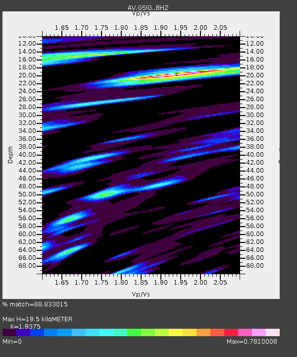
| Estimated Moho Depth: |
19.5 km |
| Estimated Crust Vp/Vs: |
1.94 |
| Assumed Crust Vp: |
3.943 km/s |
| Estimated Crust Vs: |
2.035 km/s |
| Estimated Crust Poisson's Ratio: |
0.32 |
|
| Radial Match: |
88.833015 % |
| Radial Bump: |
357 |
| Transverse Match: |
78.73745 % |
| Transverse Bump: |
400 |
| SOD ConfigId: |
25131211 |
| Insert Time: |
2021-09-22 01:53:45.921 +0000 |
| GWidth: |
2.5 |
| Max Bumps: |
400 |
| Tol: |
0.001 |
|
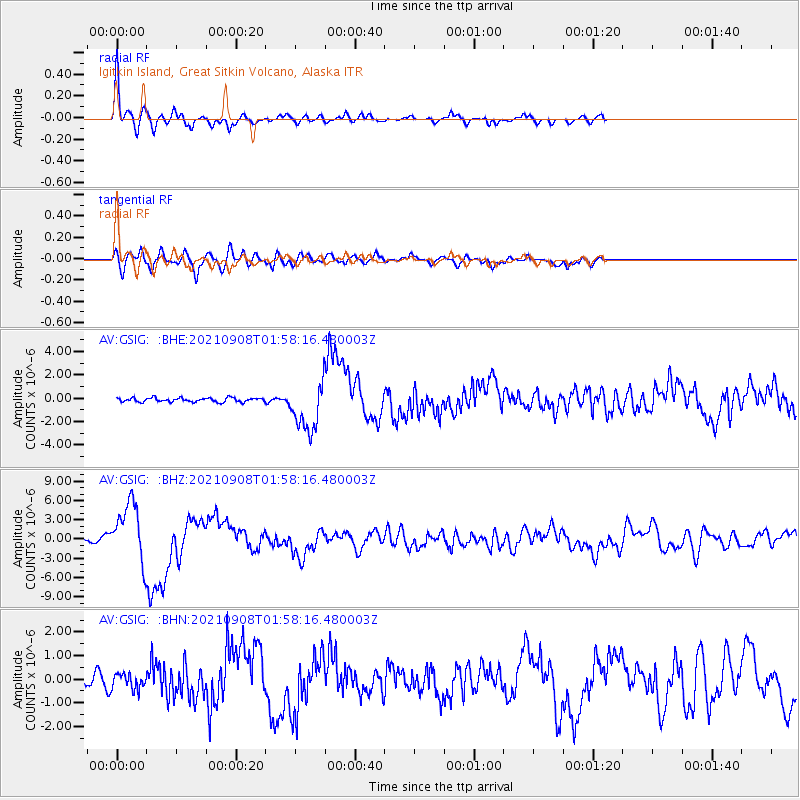
Signal To Noise
| Channel | StoN | STA | LTA |
| AV:GSIG: :BHZ:20210908T01:58:16.480003Z | 9.280754 | 4.5391844E-6 | 4.890965E-7 |
| AV:GSIG: :BHN:20210908T01:58:16.480003Z | 1.3625681 | 3.3103797E-7 | 2.429515E-7 |
| AV:GSIG: :BHE:20210908T01:58:16.480003Z | 11.887928 | 2.0884265E-6 | 1.7567625E-7 |
| Arrivals |
| Ps | 4.7 SECOND |
| PpPs | 14 SECOND |
| PsPs/PpSs | 19 SECOND |


