You are here: Home > Network List > AV - Alaska Volcano Observatory Stations List
> Station GSTR Teapot Rock, Great Sitkin Volcano, Alaska > Earthquake Result Viewer
GSTR Teapot Rock, Great Sitkin Volcano, Alaska - Earthquake Result Viewer
| Earthquake location: |
Near Coast Of Guerrero, Mexico |
| Earthquake latitude/longitude: |
17.0/-99.8 |
| Earthquake time(UTC): |
2021/09/08 (251) 01:47:46 GMT |
| Earthquake Depth: |
13 km |
| Earthquake Magnitude: |
7.0 mww |
| Earthquake Catalog/Contributor: |
NEIC PDE/us |
|
| Network: |
AV Alaska Volcano Observatory |
| Station: |
GSTR Teapot Rock, Great Sitkin Volcano, Alaska |
| Lat/Lon: |
52.09 N/176.06 W |
| Elevation: |
536 m |
|
| Distance: |
68.4 deg |
| Az: |
319.864 deg |
| Baz: |
89.998 deg |
| Ray Param: |
0.056324307 |
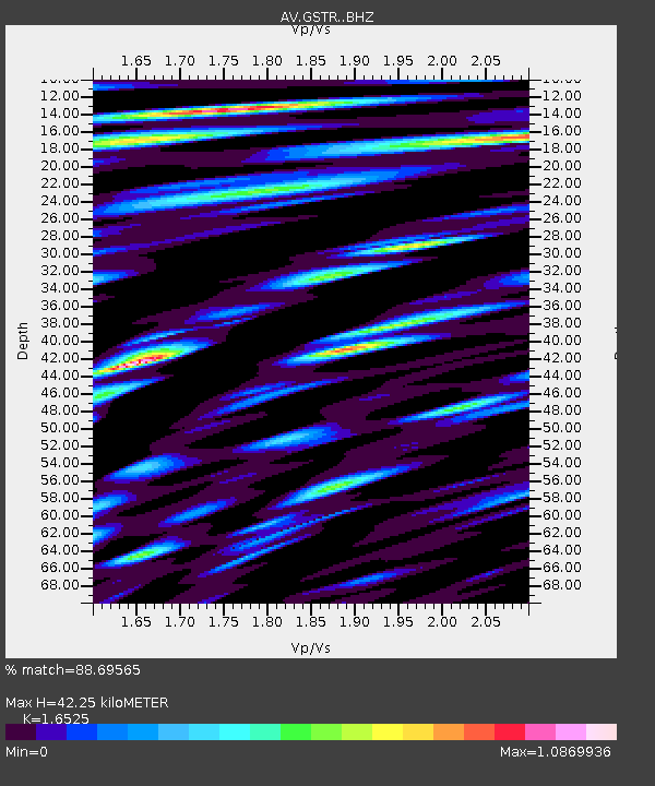
| Estimated Moho Depth: |
42.25 km |
| Estimated Crust Vp/Vs: |
1.65 |
| Assumed Crust Vp: |
3.912 km/s |
| Estimated Crust Vs: |
2.367 km/s |
| Estimated Crust Poisson's Ratio: |
0.21 |
|
| Radial Match: |
88.69565 % |
| Radial Bump: |
400 |
| Transverse Match: |
80.90317 % |
| Transverse Bump: |
400 |
| SOD ConfigId: |
25131211 |
| Insert Time: |
2021-09-22 01:53:51.868 +0000 |
| GWidth: |
2.5 |
| Max Bumps: |
400 |
| Tol: |
0.001 |
|
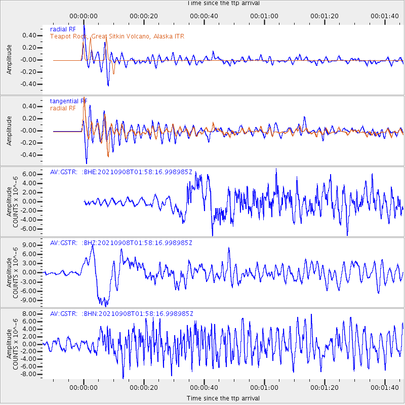
Signal To Noise
| Channel | StoN | STA | LTA |
| AV:GSTR: :BHZ:20210908T01:58:16.998985Z | 15.54217 | 5.0784183E-6 | 3.2675092E-7 |
| AV:GSTR: :BHN:20210908T01:58:16.998985Z | 1.2645606 | 1.2629368E-6 | 9.98716E-7 |
| AV:GSTR: :BHE:20210908T01:58:16.998985Z | 4.532743 | 2.5771158E-6 | 5.6855544E-7 |
| Arrivals |
| Ps | 7.2 SECOND |
| PpPs | 28 SECOND |
| PsPs/PpSs | 35 SECOND |


