You are here: Home > Network List > AV - Alaska Volcano Observatory Stations List
> Station ILLG Iliamna Volcano, Alaska > Earthquake Result Viewer
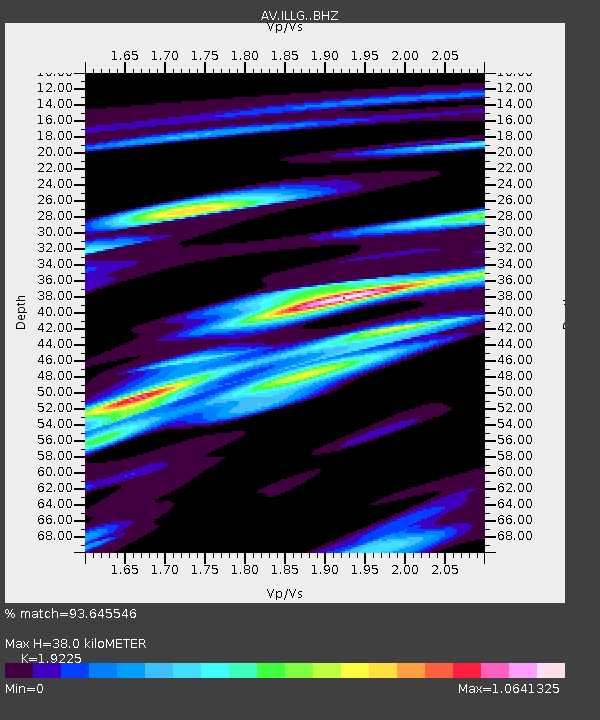
ILLG Iliamna Volcano, Alaska - Earthquake Result Viewer
| Earthquake location: |
Near Coast Of Guerrero, Mexico |
| Earthquake latitude/longitude: |
17.0/-99.8 |
| Earthquake time(UTC): |
2021/09/08 (251) 01:47:46 GMT |
| Earthquake Depth: |
13 km |
| Earthquake Magnitude: |
7.0 mww |
| Earthquake Catalog/Contributor: |
NEIC PDE/us |
|
| Network: |
AV Alaska Volcano Observatory |
| Station: |
ILLG Iliamna Volcano, Alaska |
| Lat/Lon: |
60.07 N/152.96 W |
| Elevation: |
968 m |
|
| Distance: |
57.4 deg |
| Az: |
331.554 deg |
| Baz: |
114.617 deg |
| Ray Param: |
0.0635001 |
| Estimated Moho Depth: |
38.0 km |
| Estimated Crust Vp/Vs: |
1.92 |
| Assumed Crust Vp: |
6.566 km/s |
| Estimated Crust Vs: |
3.415 km/s |
| Estimated Crust Poisson's Ratio: |
0.31 |
|
| Radial Match: |
93.645546 % |
| Radial Bump: |
400 |
| Transverse Match: |
90.30676 % |
| Transverse Bump: |
400 |
| SOD ConfigId: |
25131211 |
| Insert Time: |
2021-09-22 01:53:54.574 +0000 |
| GWidth: |
2.5 |
| Max Bumps: |
400 |
| Tol: |
0.001 |
|

Signal To Noise
| Channel | StoN | STA | LTA |
| AV:ILLG: :BHZ:20210908T01:57:04.139977Z | 146.981 | 5.694911E-6 | 3.87459E-8 |
| AV:ILLG: :BHN:20210908T01:57:04.139977Z | 29.912039 | 1.3502971E-6 | 4.5142265E-8 |
| AV:ILLG: :BHE:20210908T01:57:04.139977Z | 74.80274 | 2.5809447E-6 | 3.4503344E-8 |
| Arrivals |
| Ps | 5.6 SECOND |
| PpPs | 16 SECOND |
| PsPs/PpSs | 22 SECOND |


