You are here: Home > Network List > AV - Alaska Volcano Observatory Stations List
> Station KAVE Katnai Ventifact, Alaska > Earthquake Result Viewer
KAVE Katnai Ventifact, Alaska - Earthquake Result Viewer
| Earthquake location: |
Near Coast Of Guerrero, Mexico |
| Earthquake latitude/longitude: |
17.0/-99.8 |
| Earthquake time(UTC): |
2021/09/08 (251) 01:47:46 GMT |
| Earthquake Depth: |
13 km |
| Earthquake Magnitude: |
7.0 mww |
| Earthquake Catalog/Contributor: |
NEIC PDE/us |
|
| Network: |
AV Alaska Volcano Observatory |
| Station: |
KAVE Katnai Ventifact, Alaska |
| Lat/Lon: |
58.20 N/155.02 W |
| Elevation: |
702 m |
|
| Distance: |
57.7 deg |
| Az: |
329.014 deg |
| Baz: |
111.487 deg |
| Ray Param: |
0.06334091 |
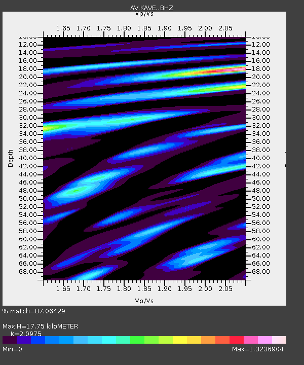
| Estimated Moho Depth: |
17.75 km |
| Estimated Crust Vp/Vs: |
2.10 |
| Assumed Crust Vp: |
6.438 km/s |
| Estimated Crust Vs: |
3.069 km/s |
| Estimated Crust Poisson's Ratio: |
0.35 |
|
| Radial Match: |
87.06429 % |
| Radial Bump: |
400 |
| Transverse Match: |
67.08227 % |
| Transverse Bump: |
400 |
| SOD ConfigId: |
25131211 |
| Insert Time: |
2021-09-22 01:54:09.591 +0000 |
| GWidth: |
2.5 |
| Max Bumps: |
400 |
| Tol: |
0.001 |
|

Signal To Noise
| Channel | StoN | STA | LTA |
| AV:KAVE: :BHZ:20210908T01:57:05.858971Z | 132.409 | 5.169381E-6 | 3.9041012E-8 |
| AV:KAVE: :BHN:20210908T01:57:05.858971Z | 21.18891 | 1.2723759E-6 | 6.0049146E-8 |
| AV:KAVE: :BHE:20210908T01:57:05.858971Z | 31.681412 | 2.0067337E-6 | 6.334105E-8 |
| Arrivals |
| Ps | 3.2 SECOND |
| PpPs | 8.2 SECOND |
| PsPs/PpSs | 11 SECOND |


