You are here: Home > Network List > AV - Alaska Volcano Observatory Stations List
> Station KIKV Kanaga Volcano, Kanaga Volcano, Alaska > Earthquake Result Viewer
KIKV Kanaga Volcano, Kanaga Volcano, Alaska - Earthquake Result Viewer
| Earthquake location: |
Near Coast Of Guerrero, Mexico |
| Earthquake latitude/longitude: |
17.0/-99.8 |
| Earthquake time(UTC): |
2021/09/08 (251) 01:47:46 GMT |
| Earthquake Depth: |
13 km |
| Earthquake Magnitude: |
7.0 mww |
| Earthquake Catalog/Contributor: |
NEIC PDE/us |
|
| Network: |
AV Alaska Volcano Observatory |
| Station: |
KIKV Kanaga Volcano, Kanaga Volcano, Alaska |
| Lat/Lon: |
51.88 N/177.17 W |
| Elevation: |
411 m |
|
| Distance: |
69.1 deg |
| Az: |
319.639 deg |
| Baz: |
89.043 deg |
| Ray Param: |
0.055876218 |
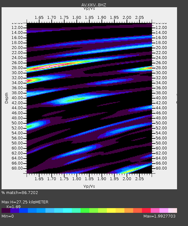
| Estimated Moho Depth: |
27.25 km |
| Estimated Crust Vp/Vs: |
1.69 |
| Assumed Crust Vp: |
5.88 km/s |
| Estimated Crust Vs: |
3.48 km/s |
| Estimated Crust Poisson's Ratio: |
0.23 |
|
| Radial Match: |
86.7202 % |
| Radial Bump: |
400 |
| Transverse Match: |
68.16029 % |
| Transverse Bump: |
400 |
| SOD ConfigId: |
25131211 |
| Insert Time: |
2021-09-22 01:54:14.019 +0000 |
| GWidth: |
2.5 |
| Max Bumps: |
400 |
| Tol: |
0.001 |
|

Signal To Noise
| Channel | StoN | STA | LTA |
| AV:KIKV: :BHZ:20210908T01:58:21.279991Z | 20.173698 | 4.5478364E-6 | 2.2543395E-7 |
| AV:KIKV: :BHN:20210908T01:58:21.279991Z | 2.1125815 | 7.366922E-7 | 3.4871658E-7 |
| AV:KIKV: :BHE:20210908T01:58:21.279991Z | 4.200999 | 2.1850703E-6 | 5.2013115E-7 |
| Arrivals |
| Ps | 3.3 SECOND |
| PpPs | 12 SECOND |
| PsPs/PpSs | 15 SECOND |


