You are here: Home > Network List > AV - Alaska Volcano Observatory Stations List
> Station KINC North Cape, Kanaga Volcano, Alaska > Earthquake Result Viewer
KINC North Cape, Kanaga Volcano, Alaska - Earthquake Result Viewer
| Earthquake location: |
Near Coast Of Guerrero, Mexico |
| Earthquake latitude/longitude: |
17.0/-99.8 |
| Earthquake time(UTC): |
2021/09/08 (251) 01:47:46 GMT |
| Earthquake Depth: |
13 km |
| Earthquake Magnitude: |
7.0 mww |
| Earthquake Catalog/Contributor: |
NEIC PDE/us |
|
| Network: |
AV Alaska Volcano Observatory |
| Station: |
KINC North Cape, Kanaga Volcano, Alaska |
| Lat/Lon: |
51.93 N/177.13 W |
| Elevation: |
198 m |
|
| Distance: |
69.1 deg |
| Az: |
319.695 deg |
| Baz: |
89.097 deg |
| Ray Param: |
0.055894706 |
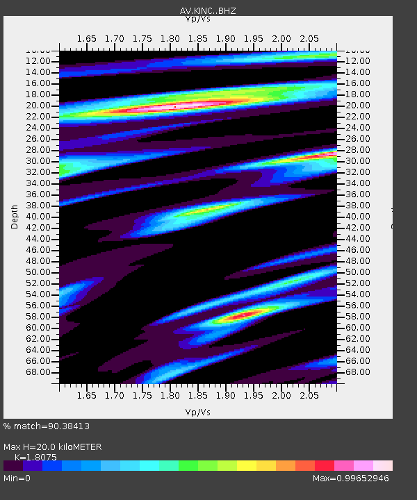
| Estimated Moho Depth: |
20.0 km |
| Estimated Crust Vp/Vs: |
1.81 |
| Assumed Crust Vp: |
5.88 km/s |
| Estimated Crust Vs: |
3.253 km/s |
| Estimated Crust Poisson's Ratio: |
0.28 |
|
| Radial Match: |
90.38413 % |
| Radial Bump: |
400 |
| Transverse Match: |
83.50821 % |
| Transverse Bump: |
400 |
| SOD ConfigId: |
25131211 |
| Insert Time: |
2021-09-22 01:54:16.913 +0000 |
| GWidth: |
2.5 |
| Max Bumps: |
400 |
| Tol: |
0.001 |
|

Signal To Noise
| Channel | StoN | STA | LTA |
| AV:KINC: :BHZ:20210908T01:58:21.11898Z | 18.094854 | 4.449033E-6 | 2.4587283E-7 |
| AV:KINC: :BHN:20210908T01:58:21.11898Z | 2.2433498 | 6.4984636E-7 | 2.896768E-7 |
| AV:KINC: :BHE:20210908T01:58:21.11898Z | 8.085529 | 2.2436705E-6 | 2.774921E-7 |
| Arrivals |
| Ps | 2.8 SECOND |
| PpPs | 9.3 SECOND |
| PsPs/PpSs | 12 SECOND |


