You are here: Home > Network List > AV - Alaska Volcano Observatory Stations List
> Station LSSE Southeast, Little Sitkin Volcano, Alaska > Earthquake Result Viewer
LSSE Southeast, Little Sitkin Volcano, Alaska - Earthquake Result Viewer
| Earthquake location: |
Near Coast Of Guerrero, Mexico |
| Earthquake latitude/longitude: |
17.0/-99.8 |
| Earthquake time(UTC): |
2021/09/08 (251) 01:47:46 GMT |
| Earthquake Depth: |
13 km |
| Earthquake Magnitude: |
7.0 mww |
| Earthquake Catalog/Contributor: |
NEIC PDE/us |
|
| Network: |
AV Alaska Volcano Observatory |
| Station: |
LSSE Southeast, Little Sitkin Volcano, Alaska |
| Lat/Lon: |
51.93 N/178.57 E |
| Elevation: |
335 m |
|
| Distance: |
71.7 deg |
| Az: |
319.824 deg |
| Baz: |
85.76 deg |
| Ray Param: |
0.054145243 |
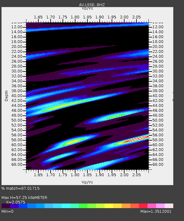
| Estimated Moho Depth: |
57.25 km |
| Estimated Crust Vp/Vs: |
2.06 |
| Assumed Crust Vp: |
6.183 km/s |
| Estimated Crust Vs: |
3.005 km/s |
| Estimated Crust Poisson's Ratio: |
0.35 |
|
| Radial Match: |
87.01715 % |
| Radial Bump: |
400 |
| Transverse Match: |
79.16268 % |
| Transverse Bump: |
400 |
| SOD ConfigId: |
25131211 |
| Insert Time: |
2021-09-22 01:54:36.820 +0000 |
| GWidth: |
2.5 |
| Max Bumps: |
400 |
| Tol: |
0.001 |
|

Signal To Noise
| Channel | StoN | STA | LTA |
| AV:LSSE: :BHZ:20210908T01:58:37.339012Z | 11.648294 | 4.4266653E-6 | 3.800269E-7 |
| AV:LSSE: :BHN:20210908T01:58:37.339012Z | 0.93068755 | 6.173155E-7 | 6.632897E-7 |
| AV:LSSE: :BHE:20210908T01:58:37.339012Z | 2.683644 | 2.438142E-6 | 9.085191E-7 |
| Arrivals |
| Ps | 10 SECOND |
| PpPs | 28 SECOND |
| PsPs/PpSs | 38 SECOND |


