You are here: Home > Network List > AV - Alaska Volcano Observatory Stations List
> Station MTBL Table Top, Makushin Volcano, Alaska > Earthquake Result Viewer
MTBL Table Top, Makushin Volcano, Alaska - Earthquake Result Viewer
| Earthquake location: |
Near Coast Of Guerrero, Mexico |
| Earthquake latitude/longitude: |
17.0/-99.8 |
| Earthquake time(UTC): |
2021/09/08 (251) 01:47:46 GMT |
| Earthquake Depth: |
13 km |
| Earthquake Magnitude: |
7.0 mww |
| Earthquake Catalog/Contributor: |
NEIC PDE/us |
|
| Network: |
AV Alaska Volcano Observatory |
| Station: |
MTBL Table Top, Makushin Volcano, Alaska |
| Lat/Lon: |
53.97 N/166.68 W |
| Elevation: |
810 m |
|
| Distance: |
62.9 deg |
| Az: |
322.375 deg |
| Baz: |
98.518 deg |
| Ray Param: |
0.05991915 |
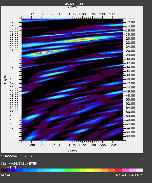
| Estimated Moho Depth: |
26.5 km |
| Estimated Crust Vp/Vs: |
1.71 |
| Assumed Crust Vp: |
3.943 km/s |
| Estimated Crust Vs: |
2.306 km/s |
| Estimated Crust Poisson's Ratio: |
0.24 |
|
| Radial Match: |
85.32987 % |
| Radial Bump: |
400 |
| Transverse Match: |
66.29977 % |
| Transverse Bump: |
400 |
| SOD ConfigId: |
25131211 |
| Insert Time: |
2021-09-22 01:54:47.958 +0000 |
| GWidth: |
2.5 |
| Max Bumps: |
400 |
| Tol: |
0.001 |
|

Signal To Noise
| Channel | StoN | STA | LTA |
| AV:MTBL: :BHZ:20210908T01:57:41.519981Z | 42.111324 | 7.0505944E-6 | 1.6742752E-7 |
| AV:MTBL: :BHN:20210908T01:57:41.519981Z | 3.266975 | 1.1907301E-6 | 3.644748E-7 |
| AV:MTBL: :BHE:20210908T01:57:41.519981Z | 7.0527477 | 3.7787902E-6 | 5.3578975E-7 |
| Arrivals |
| Ps | 4.9 SECOND |
| PpPs | 18 SECOND |
| PsPs/PpSs | 23 SECOND |


