You are here: Home > Network List > AV - Alaska Volcano Observatory Stations List
> Station P19K Oil Pt, AK, USA > Earthquake Result Viewer
P19K Oil Pt, AK, USA - Earthquake Result Viewer
| Earthquake location: |
Near Coast Of Guerrero, Mexico |
| Earthquake latitude/longitude: |
17.0/-99.8 |
| Earthquake time(UTC): |
2021/09/08 (251) 01:47:46 GMT |
| Earthquake Depth: |
13 km |
| Earthquake Magnitude: |
7.0 mww |
| Earthquake Catalog/Contributor: |
NEIC PDE/us |
|
| Network: |
AV Alaska Volcano Observatory |
| Station: |
P19K Oil Pt, AK, USA |
| Lat/Lon: |
59.65 N/153.23 W |
| Elevation: |
629 m |
|
| Distance: |
57.4 deg |
| Az: |
331.035 deg |
| Baz: |
114.104 deg |
| Ray Param: |
0.06353041 |
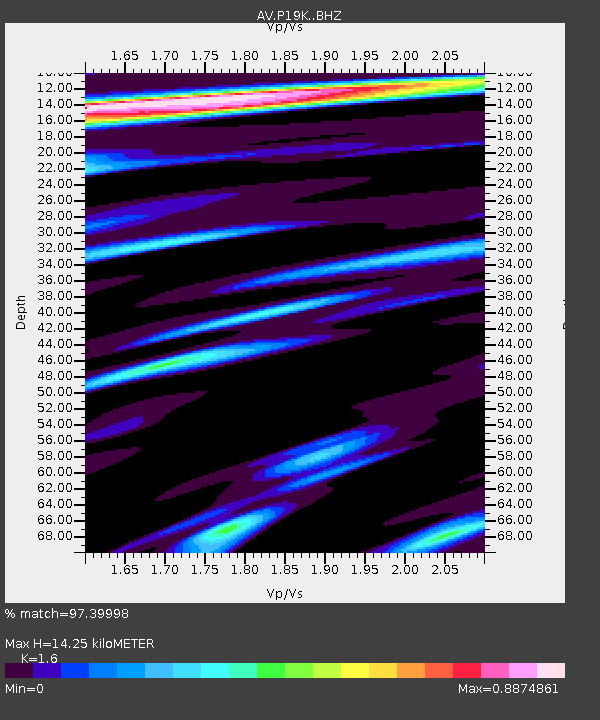
| Estimated Moho Depth: |
14.25 km |
| Estimated Crust Vp/Vs: |
1.60 |
| Assumed Crust Vp: |
5.989 km/s |
| Estimated Crust Vs: |
3.743 km/s |
| Estimated Crust Poisson's Ratio: |
0.18 |
|
| Radial Match: |
97.39998 % |
| Radial Bump: |
399 |
| Transverse Match: |
80.02111 % |
| Transverse Bump: |
400 |
| SOD ConfigId: |
25131211 |
| Insert Time: |
2021-09-22 01:54:57.971 +0000 |
| GWidth: |
2.5 |
| Max Bumps: |
400 |
| Tol: |
0.001 |
|

Signal To Noise
| Channel | StoN | STA | LTA |
| AV:P19K: :BHZ:20210908T01:57:03.824974Z | 121.76695 | 1.0708563E-5 | 8.794311E-8 |
| AV:P19K: :BHN:20210908T01:57:03.824974Z | 19.413088 | 1.8853568E-6 | 9.711783E-8 |
| AV:P19K: :BHE:20210908T01:57:03.824974Z | 37.42756 | 4.4792023E-6 | 1.1967659E-7 |
| Arrivals |
| Ps | 1.5 SECOND |
| PpPs | 5.9 SECOND |
| PsPs/PpSs | 7.4 SECOND |


