You are here: Home > Network List > AV - Alaska Volcano Observatory Stations List
> Station SSBA Shishaldin Broadband A, Shishldin Volcano, Alaska > Earthquake Result Viewer
SSBA Shishaldin Broadband A, Shishldin Volcano, Alaska - Earthquake Result Viewer
| Earthquake location: |
Near Coast Of Guerrero, Mexico |
| Earthquake latitude/longitude: |
17.0/-99.8 |
| Earthquake time(UTC): |
2021/09/08 (251) 01:47:46 GMT |
| Earthquake Depth: |
13 km |
| Earthquake Magnitude: |
7.0 mww |
| Earthquake Catalog/Contributor: |
NEIC PDE/us |
|
| Network: |
AV Alaska Volcano Observatory |
| Station: |
SSBA Shishaldin Broadband A, Shishldin Volcano, Alaska |
| Lat/Lon: |
54.77 N/164.12 W |
| Elevation: |
766 m |
|
| Distance: |
61.6 deg |
| Az: |
323.561 deg |
| Baz: |
101.145 deg |
| Ray Param: |
0.06078941 |
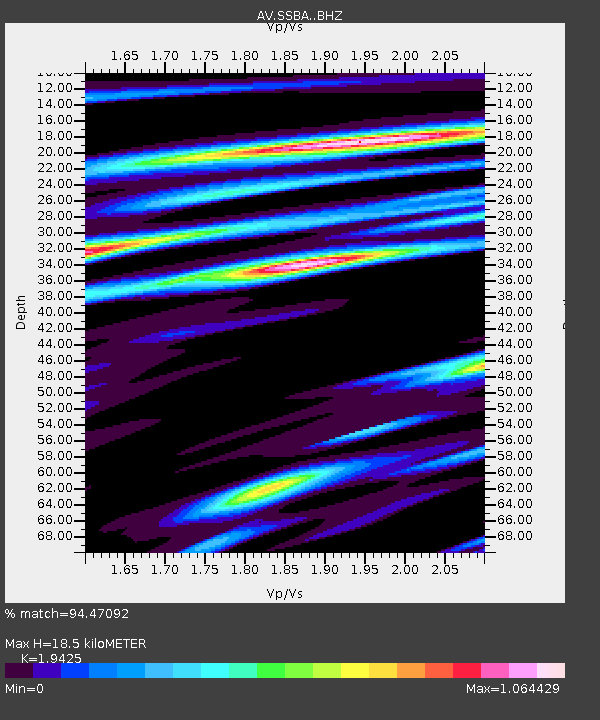
| Estimated Moho Depth: |
18.5 km |
| Estimated Crust Vp/Vs: |
1.94 |
| Assumed Crust Vp: |
5.989 km/s |
| Estimated Crust Vs: |
3.083 km/s |
| Estimated Crust Poisson's Ratio: |
0.32 |
|
| Radial Match: |
94.47092 % |
| Radial Bump: |
400 |
| Transverse Match: |
84.88123 % |
| Transverse Bump: |
400 |
| SOD ConfigId: |
25131211 |
| Insert Time: |
2021-09-22 01:55:37.830 +0000 |
| GWidth: |
2.5 |
| Max Bumps: |
400 |
| Tol: |
0.001 |
|

Signal To Noise
| Channel | StoN | STA | LTA |
| AV:SSBA: :BHZ:20210908T01:57:32.579002Z | 43.896587 | 4.5803454E-6 | 1.04344E-7 |
| AV:SSBA: :BHN:20210908T01:57:32.579002Z | 1.8386303 | 4.644929E-7 | 2.5262986E-7 |
| AV:SSBA: :BHE:20210908T01:57:32.579002Z | 9.427668 | 2.2758657E-6 | 2.4140283E-7 |
| Arrivals |
| Ps | 3.0 SECOND |
| PpPs | 8.8 SECOND |
| PsPs/PpSs | 12 SECOND |


