You are here: Home > Network List > AV - Alaska Volcano Observatory Stations List
> Station TAPA Point Aries, Tanaga Volcano, Alaska > Earthquake Result Viewer
TAPA Point Aries, Tanaga Volcano, Alaska - Earthquake Result Viewer
| Earthquake location: |
Near Coast Of Guerrero, Mexico |
| Earthquake latitude/longitude: |
17.0/-99.8 |
| Earthquake time(UTC): |
2021/09/08 (251) 01:47:46 GMT |
| Earthquake Depth: |
13 km |
| Earthquake Magnitude: |
7.0 mww |
| Earthquake Catalog/Contributor: |
NEIC PDE/us |
|
| Network: |
AV Alaska Volcano Observatory |
| Station: |
TAPA Point Aries, Tanaga Volcano, Alaska |
| Lat/Lon: |
51.81 N/177.81 W |
| Elevation: |
640 m |
|
| Distance: |
69.5 deg |
| Az: |
319.58 deg |
| Baz: |
88.519 deg |
| Ray Param: |
0.055610858 |
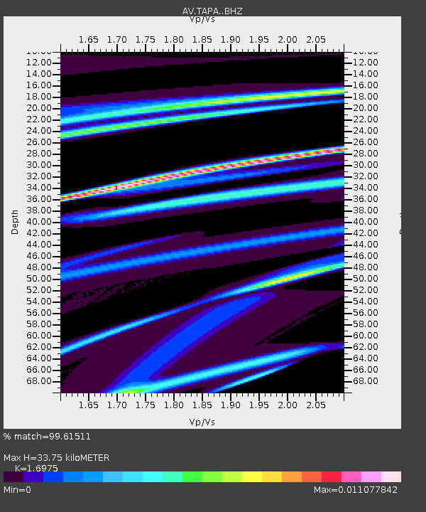
| Estimated Moho Depth: |
33.75 km |
| Estimated Crust Vp/Vs: |
1.70 |
| Assumed Crust Vp: |
5.88 km/s |
| Estimated Crust Vs: |
3.464 km/s |
| Estimated Crust Poisson's Ratio: |
0.23 |
|
| Radial Match: |
99.61511 % |
| Radial Bump: |
26 |
| Transverse Match: |
47.267906 % |
| Transverse Bump: |
400 |
| SOD ConfigId: |
25131211 |
| Insert Time: |
2021-09-22 01:55:45.801 +0000 |
| GWidth: |
2.5 |
| Max Bumps: |
400 |
| Tol: |
0.001 |
|
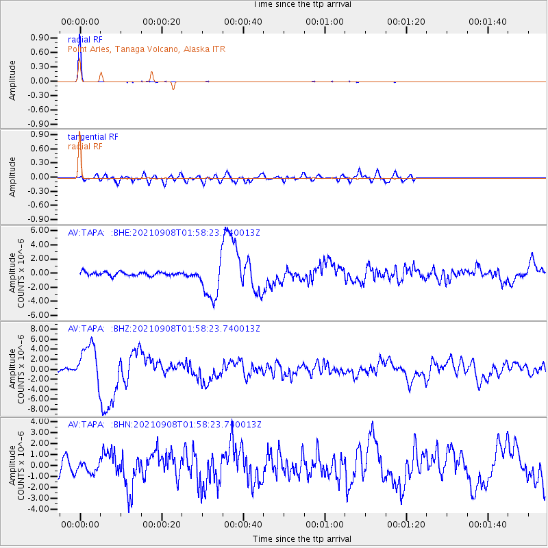
Signal To Noise
| Channel | StoN | STA | LTA |
| AV:TAPA: :BHZ:20210908T01:58:23.740013Z | 11.573426 | 4.0254245E-6 | 3.4781615E-7 |
| AV:TAPA: :BHN:20210908T01:58:23.740013Z | 1.1163031 | 4.98995E-7 | 4.4700676E-7 |
| AV:TAPA: :BHE:20210908T01:58:23.740013Z | 11.04326 | 2.8790205E-6 | 2.6070387E-7 |
| Arrivals |
| Ps | 4.1 SECOND |
| PpPs | 15 SECOND |
| PsPs/PpSs | 19 SECOND |


