You are here: Home > Network List > AV - Alaska Volcano Observatory Stations List
> Station OKTU Mount Tulik, Okmok Caldera, Alaska > Earthquake Result Viewer
OKTU Mount Tulik, Okmok Caldera, Alaska - Earthquake Result Viewer
| Earthquake location: |
Near Coast Of Guerrero, Mexico |
| Earthquake latitude/longitude: |
17.0/-99.8 |
| Earthquake time(UTC): |
2021/09/08 (251) 01:47:46 GMT |
| Earthquake Depth: |
13 km |
| Earthquake Magnitude: |
7.0 mww |
| Earthquake Catalog/Contributor: |
NEIC PDE/us |
|
| Network: |
AV Alaska Volcano Observatory |
| Station: |
OKTU Mount Tulik, Okmok Caldera, Alaska |
| Lat/Lon: |
53.38 N/168.04 W |
| Elevation: |
646 m |
|
| Distance: |
63.6 deg |
| Az: |
321.601 deg |
| Baz: |
97.075 deg |
| Ray Param: |
0.059459317 |
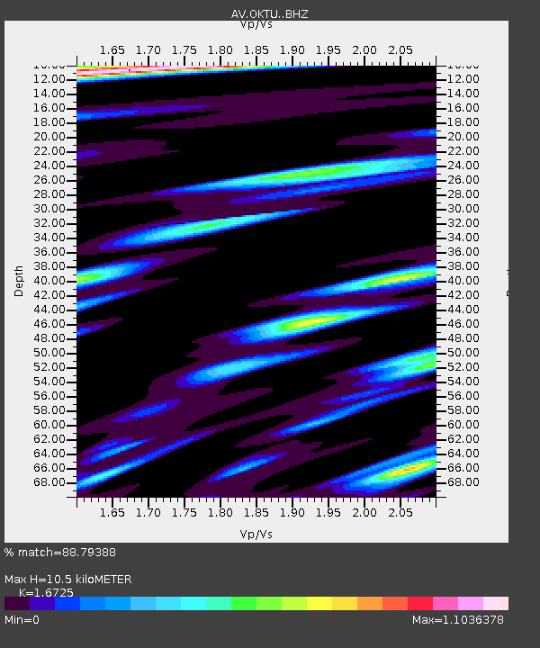
| Estimated Moho Depth: |
10.5 km |
| Estimated Crust Vp/Vs: |
1.67 |
| Assumed Crust Vp: |
5.88 km/s |
| Estimated Crust Vs: |
3.516 km/s |
| Estimated Crust Poisson's Ratio: |
0.22 |
|
| Radial Match: |
88.79388 % |
| Radial Bump: |
400 |
| Transverse Match: |
74.21826 % |
| Transverse Bump: |
400 |
| SOD ConfigId: |
25131211 |
| Insert Time: |
2021-09-22 01:56:03.947 +0000 |
| GWidth: |
2.5 |
| Max Bumps: |
400 |
| Tol: |
0.001 |
|

Signal To Noise
| Channel | StoN | STA | LTA |
| AV:OKTU: :BHZ:20210908T01:57:46.300011Z | 16.557728 | 4.788446E-6 | 2.8919706E-7 |
| AV:OKTU: :BHN:20210908T01:57:46.300011Z | 2.307105 | 8.022158E-7 | 3.4771534E-7 |
| AV:OKTU: :BHE:20210908T01:57:46.300011Z | 6.0133195 | 2.4576923E-6 | 4.0870808E-7 |
| Arrivals |
| Ps | 1.2 SECOND |
| PpPs | 4.6 SECOND |
| PsPs/PpSs | 5.8 SECOND |


