You are here: Home > Network List > AV - Alaska Volcano Observatory Stations List
> Station KAPH Katmai Pasha, Alaska > Earthquake Result Viewer
KAPH Katmai Pasha, Alaska - Earthquake Result Viewer
| Earthquake location: |
Near Coast Of Guerrero, Mexico |
| Earthquake latitude/longitude: |
17.0/-99.8 |
| Earthquake time(UTC): |
2021/09/08 (251) 01:47:46 GMT |
| Earthquake Depth: |
13 km |
| Earthquake Magnitude: |
7.0 mww |
| Earthquake Catalog/Contributor: |
NEIC PDE/us |
|
| Network: |
AV Alaska Volcano Observatory |
| Station: |
KAPH Katmai Pasha, Alaska |
| Lat/Lon: |
58.60 N/154.35 W |
| Elevation: |
907 m |
|
| Distance: |
57.5 deg |
| Az: |
329.61 deg |
| Baz: |
112.38 deg |
| Ray Param: |
0.063459195 |
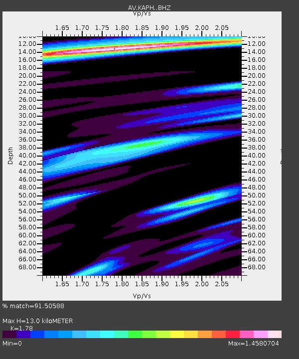
| Estimated Moho Depth: |
13.0 km |
| Estimated Crust Vp/Vs: |
1.78 |
| Assumed Crust Vp: |
6.438 km/s |
| Estimated Crust Vs: |
3.617 km/s |
| Estimated Crust Poisson's Ratio: |
0.27 |
|
| Radial Match: |
91.50588 % |
| Radial Bump: |
400 |
| Transverse Match: |
79.33326 % |
| Transverse Bump: |
400 |
| SOD ConfigId: |
25131211 |
| Insert Time: |
2021-09-22 01:56:06.812 +0000 |
| GWidth: |
2.5 |
| Max Bumps: |
400 |
| Tol: |
0.001 |
|

Signal To Noise
| Channel | StoN | STA | LTA |
| AV:KAPH: :BHZ:20210908T01:57:04.599999Z | 99.413765 | 5.2553173E-6 | 5.2863076E-8 |
| AV:KAPH: :BHN:20210908T01:57:04.599999Z | 5.751248 | 2.7387208E-7 | 4.7619594E-8 |
| AV:KAPH: :BHE:20210908T01:57:04.599999Z | 55.3336 | 2.6660348E-6 | 4.818112E-8 |
| Arrivals |
| Ps | 1.7 SECOND |
| PpPs | 5.3 SECOND |
| PsPs/PpSs | 7.0 SECOND |


