You are here: Home > Network List > AV - Alaska Volcano Observatory Stations List
> Station KVT Katmai Valley of 10,000 Smokes, Alaska > Earthquake Result Viewer
KVT Katmai Valley of 10,000 Smokes, Alaska - Earthquake Result Viewer
| Earthquake location: |
Near Coast Of Guerrero, Mexico |
| Earthquake latitude/longitude: |
17.0/-99.8 |
| Earthquake time(UTC): |
2021/09/08 (251) 01:47:46 GMT |
| Earthquake Depth: |
13 km |
| Earthquake Magnitude: |
7.0 mww |
| Earthquake Catalog/Contributor: |
NEIC PDE/us |
|
| Network: |
AV Alaska Volcano Observatory |
| Station: |
KVT Katmai Valley of 10,000 Smokes, Alaska |
| Lat/Lon: |
58.38 N/155.30 W |
| Elevation: |
457 m |
|
| Distance: |
57.9 deg |
| Az: |
329.154 deg |
| Baz: |
111.329 deg |
| Ray Param: |
0.06321043 |
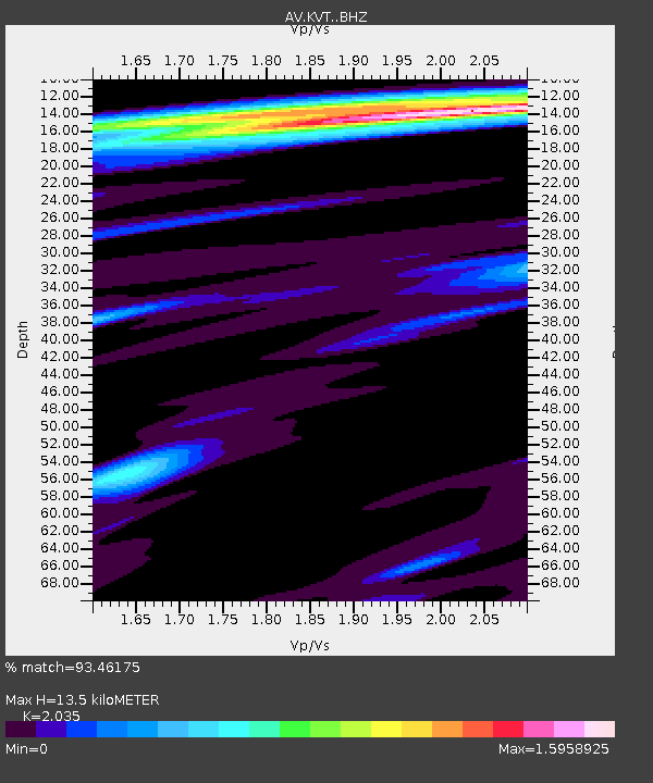
| Estimated Moho Depth: |
13.5 km |
| Estimated Crust Vp/Vs: |
2.04 |
| Assumed Crust Vp: |
6.438 km/s |
| Estimated Crust Vs: |
3.164 km/s |
| Estimated Crust Poisson's Ratio: |
0.34 |
|
| Radial Match: |
93.46175 % |
| Radial Bump: |
400 |
| Transverse Match: |
83.42944 % |
| Transverse Bump: |
400 |
| SOD ConfigId: |
25131211 |
| Insert Time: |
2021-09-22 01:56:11.448 +0000 |
| GWidth: |
2.5 |
| Max Bumps: |
400 |
| Tol: |
0.001 |
|

Signal To Noise
| Channel | StoN | STA | LTA |
| AV:KVT: :BHZ:20210908T01:57:07.279991Z | 108.131676 | 5.263079E-6 | 4.867287E-8 |
| AV:KVT: :BHN:20210908T01:57:07.279991Z | 22.584383 | 6.552412E-7 | 2.9013021E-8 |
| AV:KVT: :BHE:20210908T01:57:07.279991Z | 82.04242 | 2.4210717E-6 | 2.951E-8 |
| Arrivals |
| Ps | 2.3 SECOND |
| PpPs | 6.1 SECOND |
| PsPs/PpSs | 8.4 SECOND |


