You are here: Home > Network List > C1 - Red Sismologica Nacional Stations List
> Station ML03 Chanco > Earthquake Result Viewer
ML03 Chanco - Earthquake Result Viewer
| Earthquake location: |
Near Coast Of Guerrero, Mexico |
| Earthquake latitude/longitude: |
17.0/-99.8 |
| Earthquake time(UTC): |
2021/09/08 (251) 01:47:46 GMT |
| Earthquake Depth: |
13 km |
| Earthquake Magnitude: |
7.0 mww |
| Earthquake Catalog/Contributor: |
NEIC PDE/us |
|
| Network: |
C1 Red Sismologica Nacional |
| Station: |
ML03 Chanco |
| Lat/Lon: |
35.72 S/72.42 W |
| Elevation: |
274 m |
|
| Distance: |
58.4 deg |
| Az: |
153.963 deg |
| Baz: |
328.918 deg |
| Ray Param: |
0.06282519 |
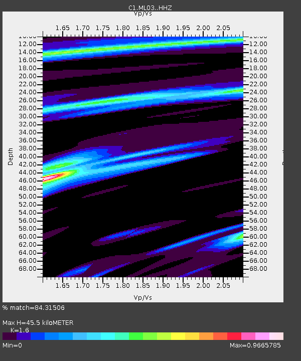
| Estimated Moho Depth: |
45.5 km |
| Estimated Crust Vp/Vs: |
1.60 |
| Assumed Crust Vp: |
6.183 km/s |
| Estimated Crust Vs: |
3.864 km/s |
| Estimated Crust Poisson's Ratio: |
0.18 |
|
| Radial Match: |
84.31506 % |
| Radial Bump: |
291 |
| Transverse Match: |
75.36866 % |
| Transverse Bump: |
382 |
| SOD ConfigId: |
25131211 |
| Insert Time: |
2021-09-22 01:57:14.603 +0000 |
| GWidth: |
2.5 |
| Max Bumps: |
400 |
| Tol: |
0.001 |
|

Signal To Noise
| Channel | StoN | STA | LTA |
| C1:ML03: :HHZ:20210908T01:57:11.282982Z | 3.7669075 | 1.3279591E-6 | 3.52533E-7 |
| C1:ML03: :HHN:20210908T01:57:11.282982Z | 0.99977225 | 4.342517E-7 | 4.3435062E-7 |
| C1:ML03: :HHE:20210908T01:57:11.282982Z | 1.4569262 | 4.328224E-7 | 2.9707914E-7 |
| Arrivals |
| Ps | 4.6 SECOND |
| PpPs | 18 SECOND |
| PsPs/PpSs | 23 SECOND |


