You are here: Home > Network List > C1 - Red Sismologica Nacional Stations List
> Station MT04 Olivares > Earthquake Result Viewer
MT04 Olivares - Earthquake Result Viewer
| Earthquake location: |
Near Coast Of Guerrero, Mexico |
| Earthquake latitude/longitude: |
17.0/-99.8 |
| Earthquake time(UTC): |
2021/09/08 (251) 01:47:46 GMT |
| Earthquake Depth: |
13 km |
| Earthquake Magnitude: |
7.0 mww |
| Earthquake Catalog/Contributor: |
NEIC PDE/us |
|
| Network: |
C1 Red Sismologica Nacional |
| Station: |
MT04 Olivares |
| Lat/Lon: |
33.40 S/70.14 W |
| Elevation: |
2082 m |
|
| Distance: |
57.5 deg |
| Az: |
150.623 deg |
| Baz: |
325.856 deg |
| Ray Param: |
0.06343987 |
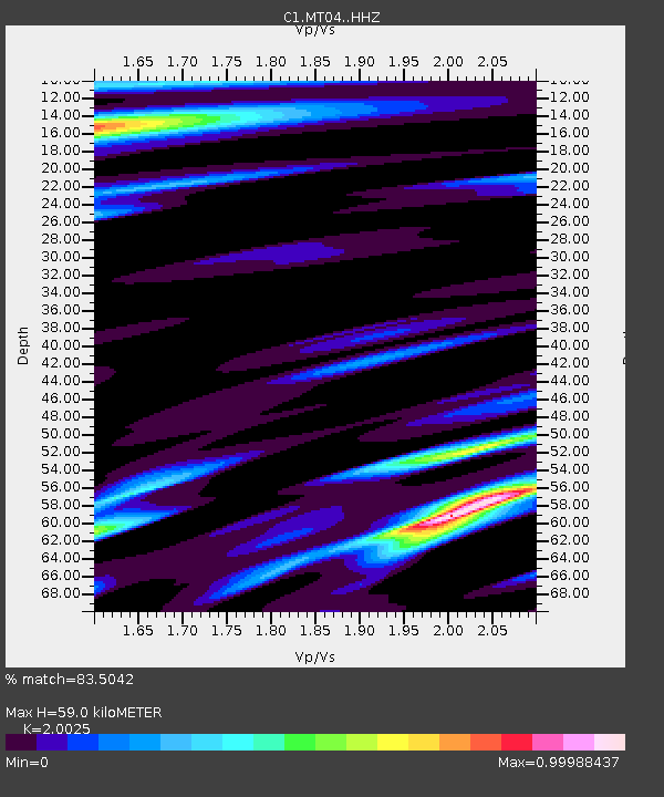
| Estimated Moho Depth: |
59.0 km |
| Estimated Crust Vp/Vs: |
2.00 |
| Assumed Crust Vp: |
6.481 km/s |
| Estimated Crust Vs: |
3.236 km/s |
| Estimated Crust Poisson's Ratio: |
0.33 |
|
| Radial Match: |
83.5042 % |
| Radial Bump: |
400 |
| Transverse Match: |
69.89891 % |
| Transverse Bump: |
400 |
| SOD ConfigId: |
25131211 |
| Insert Time: |
2021-09-22 01:57:19.948 +0000 |
| GWidth: |
2.5 |
| Max Bumps: |
400 |
| Tol: |
0.001 |
|

Signal To Noise
| Channel | StoN | STA | LTA |
| C1:MT04: :HHZ:20210908T01:57:05.159996Z | 4.312797 | 9.3436927E-7 | 2.166504E-7 |
| C1:MT04: :HHN:20210908T01:57:05.159996Z | 3.136981 | 6.1663644E-7 | 1.9657001E-7 |
| C1:MT04: :HHE:20210908T01:57:05.159996Z | 1.632324 | 5.0965355E-7 | 3.1222575E-7 |
| Arrivals |
| Ps | 9.5 SECOND |
| PpPs | 26 SECOND |
| PsPs/PpSs | 36 SECOND |


