You are here: Home > Network List > C8 - Canadian Seismic Research Network () Stations List
> Station GRIB Gribbell Island, BC, CA > Earthquake Result Viewer
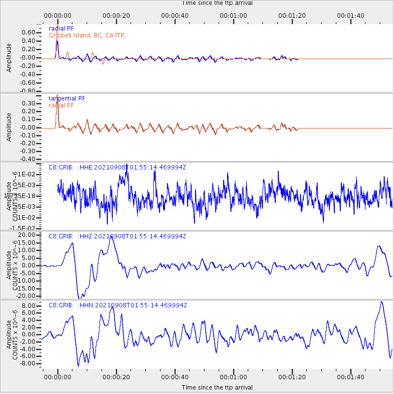
GRIB Gribbell Island, BC, CA - Earthquake Result Viewer
*The percent match for this event was below the threshold and hence no stack was calculated.
| Earthquake location: |
Near Coast Of Guerrero, Mexico |
| Earthquake latitude/longitude: |
17.0/-99.8 |
| Earthquake time(UTC): |
2021/09/08 (251) 01:47:46 GMT |
| Earthquake Depth: |
13 km |
| Earthquake Magnitude: |
7.0 mww |
| Earthquake Catalog/Contributor: |
NEIC PDE/us |
|
| Network: |
C8 Canadian Seismic Research Network () |
| Station: |
GRIB Gribbell Island, BC, CA |
| Lat/Lon: |
53.34 N/129.14 W |
| Elevation: |
418 m |
|
| Distance: |
42.9 deg |
| Az: |
334.436 deg |
| Baz: |
136.471 deg |
| Ray Param: |
$rayparam |
*The percent match for this event was below the threshold and hence was not used in the summary stack. |
|
| Radial Match: |
88.49145 % |
| Radial Bump: |
381 |
| Transverse Match: |
88.4772 % |
| Transverse Bump: |
374 |
| SOD ConfigId: |
25131211 |
| Insert Time: |
2021-09-22 01:57:44.161 +0000 |
| GWidth: |
2.5 |
| Max Bumps: |
400 |
| Tol: |
0.001 |
|
Signal To Noise
| Channel | StoN | STA | LTA |
| C8:GRIB: :HHZ:20210908T01:55:14.469994Z | 14.03243 | 7.1161803E-6 | 5.071239E-7 |
| C8:GRIB: :HHN:20210908T01:55:14.469994Z | 5.8964443 | 2.8129891E-6 | 4.770653E-7 |
| C8:GRIB: :HHE:20210908T01:55:14.469994Z | 0.9135991 | 4.5018247E-9 | 4.9275717E-9 |
| Arrivals |
| Ps | |
| PpPs | |
| PsPs/PpSs | |


