You are here: Home > Network List > C8 - Canadian Seismic Research Network () Stations List
> Station KITB Kitimat, BC, CA > Earthquake Result Viewer
KITB Kitimat, BC, CA - Earthquake Result Viewer
| Earthquake location: |
Near Coast Of Guerrero, Mexico |
| Earthquake latitude/longitude: |
17.0/-99.8 |
| Earthquake time(UTC): |
2021/09/08 (251) 01:47:46 GMT |
| Earthquake Depth: |
13 km |
| Earthquake Magnitude: |
7.0 mww |
| Earthquake Catalog/Contributor: |
NEIC PDE/us |
|
| Network: |
C8 Canadian Seismic Research Network () |
| Station: |
KITB Kitimat, BC, CA |
| Lat/Lon: |
54.08 N/128.64 W |
| Elevation: |
72 m |
|
| Distance: |
43.3 deg |
| Az: |
335.494 deg |
| Baz: |
137.646 deg |
| Ray Param: |
0.072654136 |
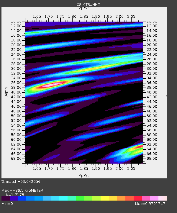
| Estimated Moho Depth: |
36.5 km |
| Estimated Crust Vp/Vs: |
1.72 |
| Assumed Crust Vp: |
6.438 km/s |
| Estimated Crust Vs: |
3.749 km/s |
| Estimated Crust Poisson's Ratio: |
0.24 |
|
| Radial Match: |
93.042656 % |
| Radial Bump: |
400 |
| Transverse Match: |
69.383125 % |
| Transverse Bump: |
400 |
| SOD ConfigId: |
25131211 |
| Insert Time: |
2021-09-22 01:57:47.120 +0000 |
| GWidth: |
2.5 |
| Max Bumps: |
400 |
| Tol: |
0.001 |
|
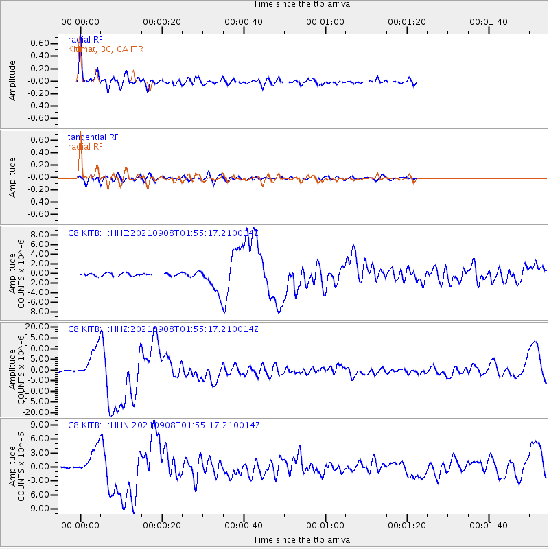
Signal To Noise
| Channel | StoN | STA | LTA |
| C8:KITB: :HHZ:20210908T01:55:17.210014Z | 17.933496 | 7.632978E-6 | 4.256269E-7 |
| C8:KITB: :HHN:20210908T01:55:17.210014Z | 7.561057 | 3.0053745E-6 | 3.9748076E-7 |
| C8:KITB: :HHE:20210908T01:55:17.210014Z | 10.444963 | 2.8770714E-6 | 2.7545062E-7 |
| Arrivals |
| Ps | 4.4 SECOND |
| PpPs | 14 SECOND |
| PsPs/PpSs | 19 SECOND |


