You are here: Home > Network List > CA - Catalan Seismic Network Stations List
> Station CPAL Palau-saverdera > Earthquake Result Viewer
CPAL Palau-saverdera - Earthquake Result Viewer
| Earthquake location: |
Near Coast Of Guerrero, Mexico |
| Earthquake latitude/longitude: |
17.0/-99.8 |
| Earthquake time(UTC): |
2021/09/08 (251) 01:47:46 GMT |
| Earthquake Depth: |
13 km |
| Earthquake Magnitude: |
7.0 mww |
| Earthquake Catalog/Contributor: |
NEIC PDE/us |
|
| Network: |
CA Catalan Seismic Network |
| Station: |
CPAL Palau-saverdera |
| Lat/Lon: |
42.31 N/3.16 E |
| Elevation: |
212 m |
|
| Distance: |
88.0 deg |
| Az: |
46.331 deg |
| Baz: |
291.039 deg |
| Ray Param: |
0.04292461 |
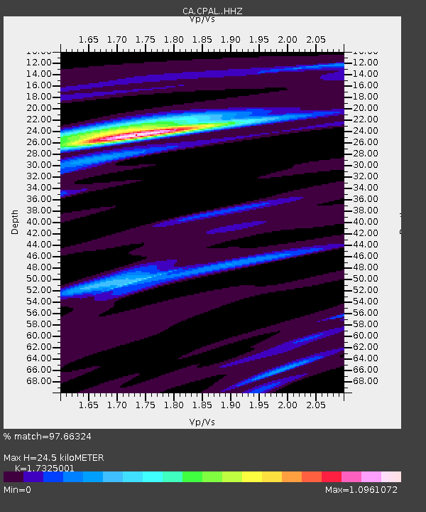
| Estimated Moho Depth: |
24.5 km |
| Estimated Crust Vp/Vs: |
1.73 |
| Assumed Crust Vp: |
6.264 km/s |
| Estimated Crust Vs: |
3.615 km/s |
| Estimated Crust Poisson's Ratio: |
0.25 |
|
| Radial Match: |
97.66324 % |
| Radial Bump: |
319 |
| Transverse Match: |
88.39219 % |
| Transverse Bump: |
400 |
| SOD ConfigId: |
25131211 |
| Insert Time: |
2021-09-22 01:58:16.053 +0000 |
| GWidth: |
2.5 |
| Max Bumps: |
400 |
| Tol: |
0.001 |
|

Signal To Noise
| Channel | StoN | STA | LTA |
| CA:CPAL: :HHZ:20210908T02:00:05.009972Z | 72.672615 | 8.236259E-6 | 1.1333373E-7 |
| CA:CPAL: :HHN:20210908T02:00:05.009972Z | 10.921714 | 6.8993324E-7 | 6.317079E-8 |
| CA:CPAL: :HHE:20210908T02:00:05.009972Z | 31.926785 | 2.69276E-6 | 8.434173E-8 |
| Arrivals |
| Ps | 2.9 SECOND |
| PpPs | 10 SECOND |
| PsPs/PpSs | 13 SECOND |


