You are here: Home > Network List > CC - Cascade Chain Volcano Monitoring Stations List
> Station KAUT Kautz Creek Helibase > Earthquake Result Viewer
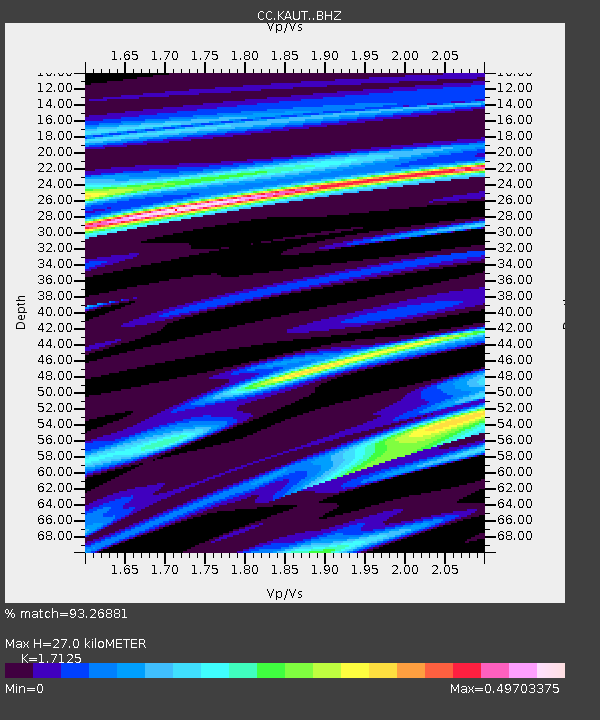
KAUT Kautz Creek Helibase - Earthquake Result Viewer
| Earthquake location: |
Near Coast Of Guerrero, Mexico |
| Earthquake latitude/longitude: |
17.0/-99.8 |
| Earthquake time(UTC): |
2021/09/08 (251) 01:47:46 GMT |
| Earthquake Depth: |
13 km |
| Earthquake Magnitude: |
7.0 mww |
| Earthquake Catalog/Contributor: |
NEIC PDE/us |
|
| Network: |
CC Cascade Chain Volcano Monitoring |
| Station: |
KAUT Kautz Creek Helibase |
| Lat/Lon: |
46.73 N/121.86 W |
| Elevation: |
689 m |
|
| Distance: |
34.9 deg |
| Az: |
333.125 deg |
| Baz: |
141.025 deg |
| Ray Param: |
0.077519745 |
| Estimated Moho Depth: |
27.0 km |
| Estimated Crust Vp/Vs: |
1.71 |
| Assumed Crust Vp: |
6.597 km/s |
| Estimated Crust Vs: |
3.853 km/s |
| Estimated Crust Poisson's Ratio: |
0.24 |
|
| Radial Match: |
93.26881 % |
| Radial Bump: |
315 |
| Transverse Match: |
82.072014 % |
| Transverse Bump: |
400 |
| SOD ConfigId: |
25131211 |
| Insert Time: |
2021-09-22 01:58:39.963 +0000 |
| GWidth: |
2.5 |
| Max Bumps: |
400 |
| Tol: |
0.001 |
|

Signal To Noise
| Channel | StoN | STA | LTA |
| CC:KAUT: :BHZ:20210908T01:54:07.08001Z | 84.881386 | 1.09661E-5 | 1.2919323E-7 |
| CC:KAUT: :BHN:20210908T01:54:07.08001Z | 23.76164 | 3.9971655E-6 | 1.6821927E-7 |
| CC:KAUT: :BHE:20210908T01:54:07.08001Z | 34.33272 | 4.849702E-6 | 1.4125597E-7 |
| Arrivals |
| Ps | 3.2 SECOND |
| PpPs | 10 SECOND |
| PsPs/PpSs | 13 SECOND |


