You are here: Home > Network List > CC - Cascade Chain Volcano Monitoring Stations List
> Station OPCH Ohanapecosh Administrative Area > Earthquake Result Viewer
OPCH Ohanapecosh Administrative Area - Earthquake Result Viewer
| Earthquake location: |
Near Coast Of Guerrero, Mexico |
| Earthquake latitude/longitude: |
17.0/-99.8 |
| Earthquake time(UTC): |
2021/09/08 (251) 01:47:46 GMT |
| Earthquake Depth: |
13 km |
| Earthquake Magnitude: |
7.0 mww |
| Earthquake Catalog/Contributor: |
NEIC PDE/us |
|
| Network: |
CC Cascade Chain Volcano Monitoring |
| Station: |
OPCH Ohanapecosh Administrative Area |
| Lat/Lon: |
46.73 N/121.57 W |
| Elevation: |
593 m |
|
| Distance: |
34.7 deg |
| Az: |
333.394 deg |
| Baz: |
141.454 deg |
| Ray Param: |
0.07758315 |
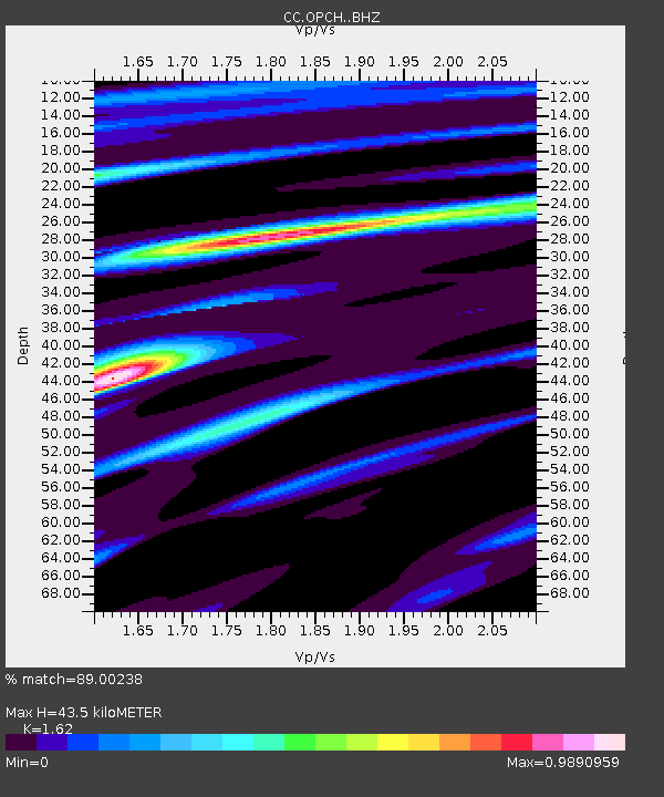
| Estimated Moho Depth: |
43.5 km |
| Estimated Crust Vp/Vs: |
1.62 |
| Assumed Crust Vp: |
6.597 km/s |
| Estimated Crust Vs: |
4.073 km/s |
| Estimated Crust Poisson's Ratio: |
0.19 |
|
| Radial Match: |
89.00238 % |
| Radial Bump: |
364 |
| Transverse Match: |
87.226776 % |
| Transverse Bump: |
334 |
| SOD ConfigId: |
25131211 |
| Insert Time: |
2021-09-22 01:58:47.670 +0000 |
| GWidth: |
2.5 |
| Max Bumps: |
400 |
| Tol: |
0.001 |
|

Signal To Noise
| Channel | StoN | STA | LTA |
| CC:OPCH: :BHZ:20210908T01:54:06.020012Z | 125.16219 | 9.998096E-6 | 7.9881126E-8 |
| CC:OPCH: :BHN:20210908T01:54:06.020012Z | 33.134277 | 5.6383788E-6 | 1.7016757E-7 |
| CC:OPCH: :BHE:20210908T01:54:06.020012Z | 21.205702 | 1.9509687E-6 | 9.200208E-8 |
| Arrivals |
| Ps | 4.5 SECOND |
| PpPs | 16 SECOND |
| PsPs/PpSs | 20 SECOND |


