You are here: Home > Network List > CC - Cascade Chain Volcano Monitoring Stations List
> Station PR03 Puyallup River 03 > Earthquake Result Viewer
PR03 Puyallup River 03 - Earthquake Result Viewer
| Earthquake location: |
Near Coast Of Guerrero, Mexico |
| Earthquake latitude/longitude: |
17.0/-99.8 |
| Earthquake time(UTC): |
2021/09/08 (251) 01:47:46 GMT |
| Earthquake Depth: |
13 km |
| Earthquake Magnitude: |
7.0 mww |
| Earthquake Catalog/Contributor: |
NEIC PDE/us |
|
| Network: |
CC Cascade Chain Volcano Monitoring |
| Station: |
PR03 Puyallup River 03 |
| Lat/Lon: |
46.90 N/122.03 W |
| Elevation: |
523 m |
|
| Distance: |
35.1 deg |
| Az: |
333.152 deg |
| Baz: |
140.92 deg |
| Ray Param: |
0.07740896 |
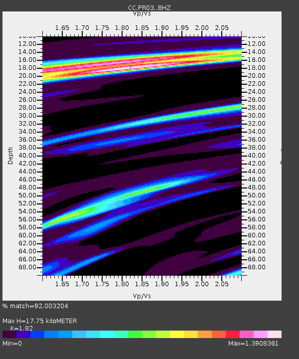
| Estimated Moho Depth: |
17.75 km |
| Estimated Crust Vp/Vs: |
1.82 |
| Assumed Crust Vp: |
6.566 km/s |
| Estimated Crust Vs: |
3.608 km/s |
| Estimated Crust Poisson's Ratio: |
0.28 |
|
| Radial Match: |
92.003204 % |
| Radial Bump: |
346 |
| Transverse Match: |
66.69824 % |
| Transverse Bump: |
400 |
| SOD ConfigId: |
25131211 |
| Insert Time: |
2021-09-22 01:58:54.311 +0000 |
| GWidth: |
2.5 |
| Max Bumps: |
400 |
| Tol: |
0.001 |
|

Signal To Noise
| Channel | StoN | STA | LTA |
| CC:PR03: :BHZ:20210908T01:54:08.879997Z | 130.9275 | 1.0926321E-5 | 8.345321E-8 |
| CC:PR03: :BHN:20210908T01:54:08.879997Z | 28.607311 | 5.4776397E-6 | 1.914769E-7 |
| CC:PR03: :BHE:20210908T01:54:08.879997Z | 21.302143 | 2.8436486E-6 | 1.3349121E-7 |
| Arrivals |
| Ps | 2.4 SECOND |
| PpPs | 7.1 SECOND |
| PsPs/PpSs | 9.4 SECOND |


