You are here: Home > Network List > CC - Cascade Chain Volcano Monitoring Stations List
> Station YOCR Yocum Ridge > Earthquake Result Viewer
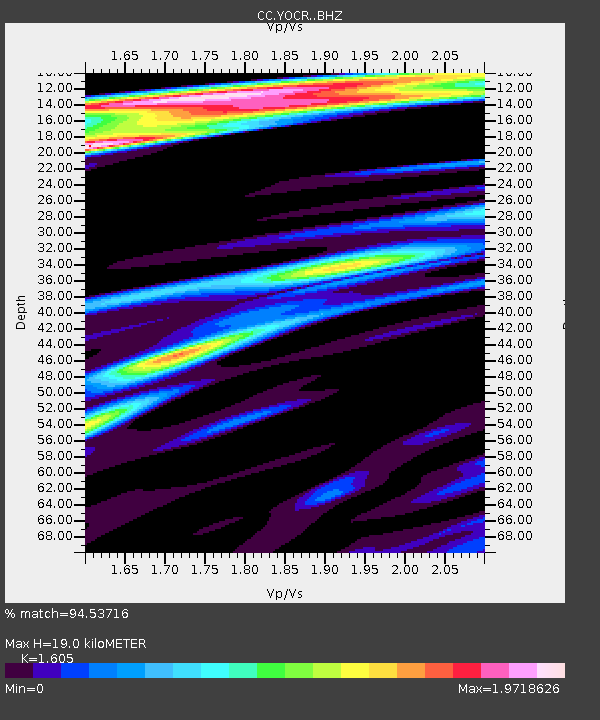
YOCR Yocum Ridge - Earthquake Result Viewer
| Earthquake location: |
Near Coast Of Guerrero, Mexico |
| Earthquake latitude/longitude: |
17.0/-99.8 |
| Earthquake time(UTC): |
2021/09/08 (251) 01:47:46 GMT |
| Earthquake Depth: |
13 km |
| Earthquake Magnitude: |
7.0 mww |
| Earthquake Catalog/Contributor: |
NEIC PDE/us |
|
| Network: |
CC Cascade Chain Volcano Monitoring |
| Station: |
YOCR Yocum Ridge |
| Lat/Lon: |
45.38 N/121.74 W |
| Elevation: |
1914 m |
|
| Distance: |
33.8 deg |
| Az: |
331.708 deg |
| Baz: |
139.937 deg |
| Ray Param: |
0.07806107 |
| Estimated Moho Depth: |
19.0 km |
| Estimated Crust Vp/Vs: |
1.61 |
| Assumed Crust Vp: |
6.597 km/s |
| Estimated Crust Vs: |
4.111 km/s |
| Estimated Crust Poisson's Ratio: |
0.18 |
|
| Radial Match: |
94.53716 % |
| Radial Bump: |
400 |
| Transverse Match: |
78.91357 % |
| Transverse Bump: |
400 |
| SOD ConfigId: |
25131211 |
| Insert Time: |
2021-09-22 01:59:22.784 +0000 |
| GWidth: |
2.5 |
| Max Bumps: |
400 |
| Tol: |
0.001 |
|

Signal To Noise
| Channel | StoN | STA | LTA |
| CC:YOCR: :BHZ:20210908T01:53:57.640007Z | 87.58315 | 1.0144821E-5 | 1.15830744E-7 |
| CC:YOCR: :BHN:20210908T01:53:57.640007Z | 36.81357 | 5.808095E-6 | 1.5777051E-7 |
| CC:YOCR: :BHE:20210908T01:53:57.640007Z | 37.126038 | 3.8248913E-6 | 1.03024504E-7 |
| Arrivals |
| Ps | 1.9 SECOND |
| PpPs | 6.8 SECOND |
| PsPs/PpSs | 8.8 SECOND |


